You are here: Home > Network List > AU - Australian Seismological Centre Stations List
> Station ARMA Armidale, New South Wales > Earthquake Result Viewer
ARMA Armidale, New South Wales - Earthquake Result Viewer
| Earthquake location: |
Celebes Sea |
| Earthquake latitude/longitude: |
4.1/122.4 |
| Earthquake time(UTC): |
2009/10/07 (280) 21:41:13 GMT |
| Earthquake Depth: |
574 km |
| Earthquake Magnitude: |
6.3 MB, 6.8 MW, 6.8 MW |
| Earthquake Catalog/Contributor: |
WHDF/NEIC |
|
| Network: |
AU Australian Seismological Centre |
| Station: |
ARMA Armidale, New South Wales |
| Lat/Lon: |
30.42 S/151.63 E |
| Elevation: |
1112 m |
|
| Distance: |
44.3 deg |
| Az: |
142.778 deg |
| Baz: |
315.692 deg |
| Ray Param: |
0.069183506 |
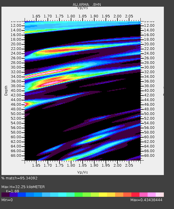
| Estimated Moho Depth: |
32.25 km |
| Estimated Crust Vp/Vs: |
1.69 |
| Assumed Crust Vp: |
6.577 km/s |
| Estimated Crust Vs: |
3.892 km/s |
| Estimated Crust Poisson's Ratio: |
0.23 |
|
| Radial Match: |
95.34092 % |
| Radial Bump: |
294 |
| Transverse Match: |
86.49827 % |
| Transverse Bump: |
400 |
| SOD ConfigId: |
2622 |
| Insert Time: |
2010-03-08 23:29:12.885 +0000 |
| GWidth: |
2.5 |
| Max Bumps: |
400 |
| Tol: |
0.001 |
|

Signal To Noise
| Channel | StoN | STA | LTA |
| AU:ARMA: :BHN:20091007T21:48:02.020Z | 6.986696 | 4.5187767E-6 | 6.467688E-7 |
| AU:ARMA: :BHE:20091007T21:48:02.020Z | 6.622202 | 2.1777491E-6 | 3.2885572E-7 |
| AU:ARMA: :BHZ:20091007T21:48:02.020Z | 4.7879977 | 1.950095E-6 | 4.072882E-7 |
| Arrivals |
| Ps | 3.6 SECOND |
| PpPs | 12 SECOND |
| PsPs/PpSs | 16 SECOND |


