You are here: Home > Network List > US - United States National Seismic Network Stations List
> Station OXF Oxford, Mississippi, USA > Earthquake Result Viewer
OXF Oxford, Mississippi, USA - Earthquake Result Viewer
| Earthquake location: |
Komandorskiye Ostrova Region |
| Earthquake latitude/longitude: |
54.2/169.2 |
| Earthquake time(UTC): |
2017/07/17 (198) 23:34:21 GMT |
| Earthquake Depth: |
48 km |
| Earthquake Magnitude: |
7.4 Mi |
| Earthquake Catalog/Contributor: |
NEIC PDE/pt |
|
| Network: |
US United States National Seismic Network |
| Station: |
OXF Oxford, Mississippi, USA |
| Lat/Lon: |
34.51 N/89.41 W |
| Elevation: |
101 m |
|
| Distance: |
68.9 deg |
| Az: |
60.214 deg |
| Baz: |
321.866 deg |
| Ray Param: |
0.055929013 |
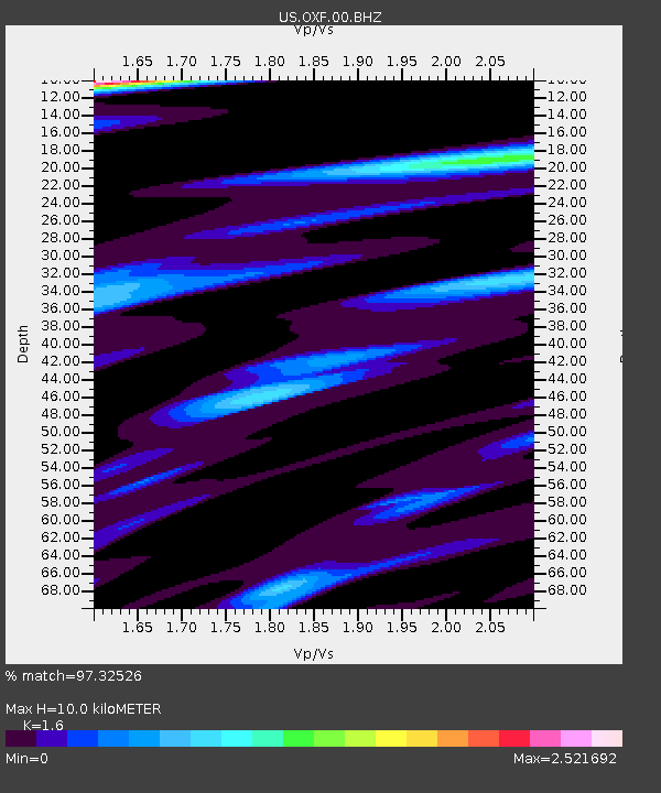
| Estimated Moho Depth: |
10.0 km |
| Estimated Crust Vp/Vs: |
1.60 |
| Assumed Crust Vp: |
6.38 km/s |
| Estimated Crust Vs: |
3.988 km/s |
| Estimated Crust Poisson's Ratio: |
0.18 |
|
| Radial Match: |
97.32526 % |
| Radial Bump: |
351 |
| Transverse Match: |
95.82845 % |
| Transverse Bump: |
400 |
| SOD ConfigId: |
2140511 |
| Insert Time: |
2017-07-31 15:41:23.561 +0000 |
| GWidth: |
2.5 |
| Max Bumps: |
400 |
| Tol: |
0.001 |
|
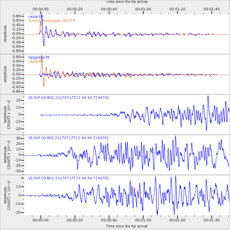
Signal To Noise
| Channel | StoN | STA | LTA |
| US:OXF:00:BHZ:20170717T23:44:49.724976Z | 11.918867 | 1.095937E-6 | 9.194977E-8 |
| US:OXF:00:BH1:20170717T23:44:49.724976Z | 4.728925 | 6.249491E-7 | 1.3215458E-7 |
| US:OXF:00:BH2:20170717T23:44:49.724976Z | 2.5022528 | 4.13542E-7 | 1.6526788E-7 |
| Arrivals |
| Ps | 1.0 SECOND |
| PpPs | 3.9 SECOND |
| PsPs/PpSs | 4.9 SECOND |


