You are here: Home > Network List > AU - Australian Seismological Centre Stations List
> Station ARMA Armidale, New South Wales > Earthquake Result Viewer
ARMA Armidale, New South Wales - Earthquake Result Viewer
| Earthquake location: |
Kuril Islands |
| Earthquake latitude/longitude: |
46.0/151.5 |
| Earthquake time(UTC): |
2009/04/07 (097) 04:23:33 GMT |
| Earthquake Depth: |
31 km |
| Earthquake Magnitude: |
6.5 MB, 6.8 MS, 6.9 MW, 6.9 MW |
| Earthquake Catalog/Contributor: |
WHDF/NEIC |
|
| Network: |
AU Australian Seismological Centre |
| Station: |
ARMA Armidale, New South Wales |
| Lat/Lon: |
30.42 S/151.63 E |
| Elevation: |
1112 m |
|
| Distance: |
76.1 deg |
| Az: |
179.928 deg |
| Baz: |
359.942 deg |
| Ray Param: |
0.051174007 |
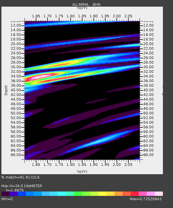
| Estimated Moho Depth: |
34.0 km |
| Estimated Crust Vp/Vs: |
1.67 |
| Assumed Crust Vp: |
6.577 km/s |
| Estimated Crust Vs: |
3.944 km/s |
| Estimated Crust Poisson's Ratio: |
0.22 |
|
| Radial Match: |
91.913216 % |
| Radial Bump: |
400 |
| Transverse Match: |
79.43842 % |
| Transverse Bump: |
400 |
| SOD ConfigId: |
2658 |
| Insert Time: |
2010-03-08 23:29:34.467 +0000 |
| GWidth: |
2.5 |
| Max Bumps: |
400 |
| Tol: |
0.001 |
|

Signal To Noise
| Channel | StoN | STA | LTA |
| AU:ARMA: :BHN:20090407T04:34:46.769019Z | 7.1604133 | 2.9417788E-6 | 4.1083928E-7 |
| AU:ARMA: :BHE:20090407T04:34:46.769019Z | 6.6180367 | 1.3700657E-6 | 2.0701995E-7 |
| AU:ARMA: :BHZ:20090407T04:34:46.769019Z | 1.0935235 | 3.743878E-7 | 3.4236834E-7 |
| Arrivals |
| Ps | 3.6 SECOND |
| PpPs | 13 SECOND |
| PsPs/PpSs | 17 SECOND |


