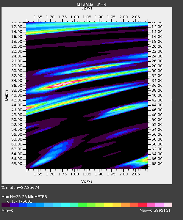
ARMA Armidale, New South Wales - Earthquake Result Viewer

Earthquake location: Talaud Islands, Indonesia
Earthquake latitude/longitude: 4.0/126.5
Earthquake time(UTC): 2009/02/12 (043) 13:15:06 GMT
Earthquake Depth: 26 km
Earthquake Magnitude: 6.1 MB, 6.1 MS, 6.3 MW, 6.3 MW
Earthquake Catalog/Contributor: WHDF/NEIC
Network: AU Australian Seismological Centre
Station: ARMA Armidale, New South Wales
Lat/Lon: 30.42 S/151.63 E
Elevation: 1112 m
Distance: 41.8 deg
Az: 146.691 deg
Baz: 320.642 deg
Ray Param: 0.07350372
Estimated Moho Depth: 35.25 km
Estimated Crust Vp/Vs: 1.75
Assumed Crust Vp: 6.577 km/s
Estimated Crust Vs: 3.763 km/s
Estimated Crust Poisson's Ratio: 0.26
Radial Match: 87.35674 %
Radial Bump: 305
Transverse Match: 76.081314 %
Transverse Bump: 400
SOD ConfigId: 2658
Insert Time: 2010-03-08 23:29:36.235 +0000
GWidth: 2.5
Max Bumps: 400
Tol: 0.001

Signal To Noise

ChannelStoNSTALTA
AU:ARMA: :BHN:20090212T13:22:22.945002Z6.18592171.4247668E-62.3032408E-7
AU:ARMA: :BHE:20090212T13:22:22.945002Z3.92511639.519615E-72.4253077E-7
AU:ARMA: :BHZ:20090212T13:22:22.945002Z3.41842916.566794E-71.9209975E-7
Arrivals
Ps4.3 SECOND
PpPs14 SECOND
PsPs/PpSs18 SECOND