You are here: Home > Network List > TX - Texas Seismological Network Stations List
> Station ALPN Alpine > Earthquake Result Viewer
ALPN Alpine - Earthquake Result Viewer
| Earthquake location: |
Komandorskiye Ostrova Region |
| Earthquake latitude/longitude: |
54.2/169.2 |
| Earthquake time(UTC): |
2017/07/17 (198) 23:34:21 GMT |
| Earthquake Depth: |
48 km |
| Earthquake Magnitude: |
7.4 Mi |
| Earthquake Catalog/Contributor: |
NEIC PDE/pt |
|
| Network: |
TX Texas Seismological Network |
| Station: |
ALPN Alpine |
| Lat/Lon: |
30.37 N/103.64 W |
| Elevation: |
1368 m |
|
| Distance: |
64.4 deg |
| Az: |
73.177 deg |
| Baz: |
319.401 deg |
| Ray Param: |
0.058854867 |
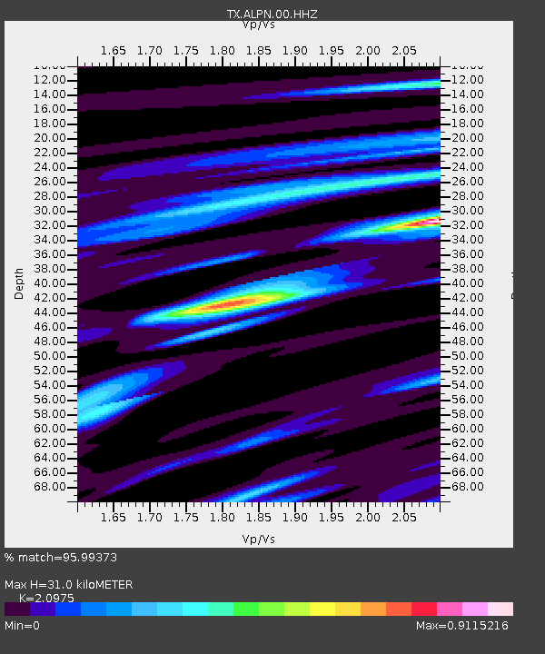
| Estimated Moho Depth: |
31.0 km |
| Estimated Crust Vp/Vs: |
2.10 |
| Assumed Crust Vp: |
6.121 km/s |
| Estimated Crust Vs: |
2.918 km/s |
| Estimated Crust Poisson's Ratio: |
0.35 |
|
| Radial Match: |
95.99373 % |
| Radial Bump: |
276 |
| Transverse Match: |
87.35312 % |
| Transverse Bump: |
400 |
| SOD ConfigId: |
2140511 |
| Insert Time: |
2017-07-31 15:43:39.203 +0000 |
| GWidth: |
2.5 |
| Max Bumps: |
400 |
| Tol: |
0.001 |
|

Signal To Noise
| Channel | StoN | STA | LTA |
| TX:ALPN:00:HHZ:20170717T23:44:21.234985Z | 7.0001597 | 8.0905903E-7 | 1.1557723E-7 |
| TX:ALPN:00:HH1:20170717T23:44:21.234985Z | 1.6968029 | 6.5306224E-8 | 3.848781E-8 |
| TX:ALPN:00:HH2:20170717T23:44:21.234985Z | 6.636612 | 4.15362E-7 | 6.258645E-8 |
| Arrivals |
| Ps | 5.7 SECOND |
| PpPs | 15 SECOND |
| PsPs/PpSs | 21 SECOND |


