You are here: Home > Network List > JP - Japan Meteorological Agency Seismic Network Stations List
> Station JWT Kyoto Wachi > Earthquake Result Viewer
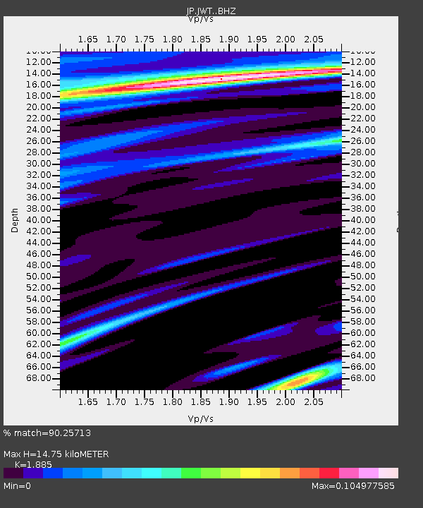
JWT Kyoto Wachi - Earthquake Result Viewer
| Earthquake location: |
Turkey |
| Earthquake latitude/longitude: |
38.2/38.7 |
| Earthquake time(UTC): |
2020/08/04 (217) 09:37:37 GMT |
| Earthquake Depth: |
10 km |
| Earthquake Magnitude: |
5.5 mww |
| Earthquake Catalog/Contributor: |
NEIC PDE/us |
|
| Network: |
JP Japan Meteorological Agency Seismic Network |
| Station: |
JWT Kyoto Wachi |
| Lat/Lon: |
35.29 N/135.40 E |
| Elevation: |
172 m |
|
| Distance: |
73.8 deg |
| Az: |
57.796 deg |
| Baz: |
305.432 deg |
| Ray Param: |
0.05277535 |
| Estimated Moho Depth: |
14.75 km |
| Estimated Crust Vp/Vs: |
1.88 |
| Assumed Crust Vp: |
6.468 km/s |
| Estimated Crust Vs: |
3.431 km/s |
| Estimated Crust Poisson's Ratio: |
0.30 |
|
| Radial Match: |
90.25713 % |
| Radial Bump: |
291 |
| Transverse Match: |
99.67522 % |
| Transverse Bump: |
58 |
| SOD ConfigId: |
21709731 |
| Insert Time: |
2020-08-18 09:45:19.911 +0000 |
| GWidth: |
2.5 |
| Max Bumps: |
400 |
| Tol: |
0.001 |
|

Signal To Noise
| Channel | StoN | STA | LTA |
| JP:JWT: :BHZ:20200804T09:48:40.350025Z | 2.1272035 | 4.6042178E-8 | 2.1644464E-8 |
| JP:JWT: :BHN:20200804T09:48:40.350025Z | 2.118301 | 4.440882E-8 | 2.0964357E-8 |
| JP:JWT: :BHE:20200804T09:48:40.350025Z | 1.9476205 | 3.34318E-8 | 1.7165458E-8 |
| Arrivals |
| Ps | 2.1 SECOND |
| PpPs | 6.4 SECOND |
| PsPs/PpSs | 8.5 SECOND |


