You are here: Home > Network List > TX - Texas Seismological Network Stations List
> Station SN04 Snyder 4 > Earthquake Result Viewer
SN04 Snyder 4 - Earthquake Result Viewer
| Earthquake location: |
Komandorskiye Ostrova Region |
| Earthquake latitude/longitude: |
54.2/169.2 |
| Earthquake time(UTC): |
2017/07/17 (198) 23:34:21 GMT |
| Earthquake Depth: |
48 km |
| Earthquake Magnitude: |
7.4 Mi |
| Earthquake Catalog/Contributor: |
NEIC PDE/pt |
|
| Network: |
TX Texas Seismological Network |
| Station: |
SN04 Snyder 4 |
| Lat/Lon: |
32.90 N/100.87 W |
| Elevation: |
716 m |
|
| Distance: |
64.0 deg |
| Az: |
69.366 deg |
| Baz: |
319.188 deg |
| Ray Param: |
0.059091277 |
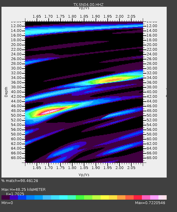
| Estimated Moho Depth: |
48.25 km |
| Estimated Crust Vp/Vs: |
1.70 |
| Assumed Crust Vp: |
6.426 km/s |
| Estimated Crust Vs: |
3.775 km/s |
| Estimated Crust Poisson's Ratio: |
0.24 |
|
| Radial Match: |
98.46126 % |
| Radial Bump: |
287 |
| Transverse Match: |
96.78381 % |
| Transverse Bump: |
353 |
| SOD ConfigId: |
2140511 |
| Insert Time: |
2017-07-31 15:44:36.162 +0000 |
| GWidth: |
2.5 |
| Max Bumps: |
400 |
| Tol: |
0.001 |
|
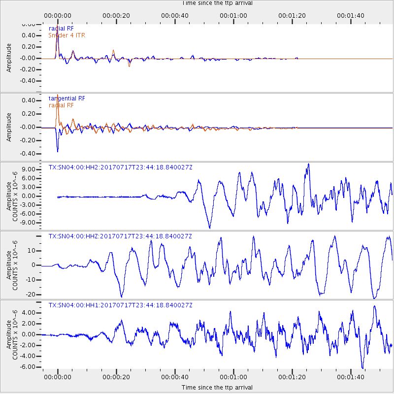
Signal To Noise
| Channel | StoN | STA | LTA |
| TX:SN04:00:HHZ:20170717T23:44:18.840027Z | 20.154493 | 1.0513546E-6 | 5.2164776E-8 |
| TX:SN04:00:HH1:20170717T23:44:18.840027Z | 1.081177 | 1.3785248E-7 | 1.2750225E-7 |
| TX:SN04:00:HH2:20170717T23:44:18.840027Z | 7.964624 | 5.1699277E-7 | 6.4911134E-8 |
| Arrivals |
| Ps | 5.5 SECOND |
| PpPs | 19 SECOND |
| PsPs/PpSs | 25 SECOND |


