You are here: Home > Network List > CI - Caltech Regional Seismic Network Stations List
> Station MPM Manuel Prospect Mine, California, USA > Earthquake Result Viewer
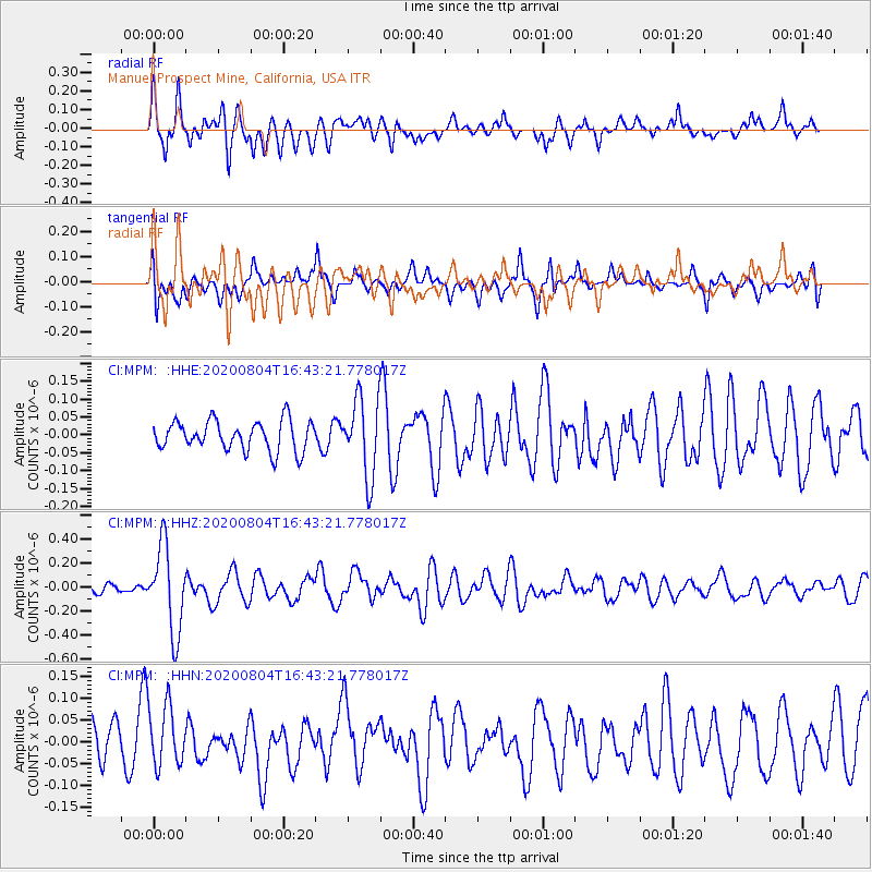
MPM Manuel Prospect Mine, California, USA - Earthquake Result Viewer
*The percent match for this event was below the threshold and hence no stack was calculated.
| Earthquake location: |
Santa Cruz Islands |
| Earthquake latitude/longitude: |
-12.6/166.6 |
| Earthquake time(UTC): |
2020/08/04 (217) 16:31:19 GMT |
| Earthquake Depth: |
70 km |
| Earthquake Magnitude: |
5.6 mww |
| Earthquake Catalog/Contributor: |
NEIC PDE/us |
|
| Network: |
CI Caltech Regional Seismic Network |
| Station: |
MPM Manuel Prospect Mine, California, USA |
| Lat/Lon: |
36.06 N/117.49 W |
| Elevation: |
185 m |
|
| Distance: |
86.2 deg |
| Az: |
51.963 deg |
| Baz: |
251.611 deg |
| Ray Param: |
$rayparam |
*The percent match for this event was below the threshold and hence was not used in the summary stack. |
|
| Radial Match: |
76.72848 % |
| Radial Bump: |
400 |
| Transverse Match: |
54.31494 % |
| Transverse Bump: |
400 |
| SOD ConfigId: |
21709731 |
| Insert Time: |
2020-08-18 16:38:47.524 +0000 |
| GWidth: |
2.5 |
| Max Bumps: |
400 |
| Tol: |
0.001 |
|
Signal To Noise
| Channel | StoN | STA | LTA |
| CI:MPM: :HHZ:20200804T16:43:21.778017Z | 5.8009276 | 3.582964E-7 | 6.176536E-8 |
| CI:MPM: :HHN:20200804T16:43:21.778017Z | 1.1081527 | 7.001182E-8 | 6.317885E-8 |
| CI:MPM: :HHE:20200804T16:43:21.778017Z | 2.593708 | 1.07585976E-7 | 4.1479602E-8 |
| Arrivals |
| Ps | |
| PpPs | |
| PsPs/PpSs | |


