You are here: Home > Network List > TA - USArray Transportable Network (new EarthScope stations) Stations List
> Station G21K Allakaket, AK, USA > Earthquake Result Viewer
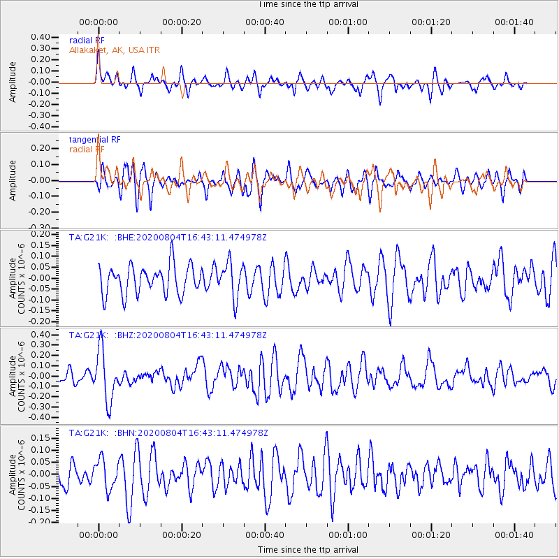
G21K Allakaket, AK, USA - Earthquake Result Viewer
*The percent match for this event was below the threshold and hence no stack was calculated.
| Earthquake location: |
Santa Cruz Islands |
| Earthquake latitude/longitude: |
-12.6/166.6 |
| Earthquake time(UTC): |
2020/08/04 (217) 16:31:19 GMT |
| Earthquake Depth: |
70 km |
| Earthquake Magnitude: |
5.6 mww |
| Earthquake Catalog/Contributor: |
NEIC PDE/us |
|
| Network: |
TA USArray Transportable Network (new EarthScope stations) |
| Station: |
G21K Allakaket, AK, USA |
| Lat/Lon: |
66.52 N/153.51 W |
| Elevation: |
446 m |
|
| Distance: |
84.2 deg |
| Az: |
14.973 deg |
| Baz: |
219.006 deg |
| Ray Param: |
$rayparam |
*The percent match for this event was below the threshold and hence was not used in the summary stack. |
|
| Radial Match: |
57.177906 % |
| Radial Bump: |
400 |
| Transverse Match: |
59.774334 % |
| Transverse Bump: |
400 |
| SOD ConfigId: |
21709731 |
| Insert Time: |
2020-08-18 16:46:17.688 +0000 |
| GWidth: |
2.5 |
| Max Bumps: |
400 |
| Tol: |
0.001 |
|
Signal To Noise
| Channel | StoN | STA | LTA |
| TA:G21K: :BHZ:20200804T16:43:11.474978Z | 4.1762176 | 2.541012E-7 | 6.084482E-8 |
| TA:G21K: :BHN:20200804T16:43:11.474978Z | 1.3630359 | 6.26943E-8 | 4.599607E-8 |
| TA:G21K: :BHE:20200804T16:43:11.474978Z | 1.2671072 | 8.368194E-8 | 6.6041714E-8 |
| Arrivals |
| Ps | |
| PpPs | |
| PsPs/PpSs | |


