You are here: Home > Network List > IU - Global Seismograph Network (GSN - IRIS/USGS) Stations List
> Station CCM Cathedral Cave, Missouri, USA > Earthquake Result Viewer
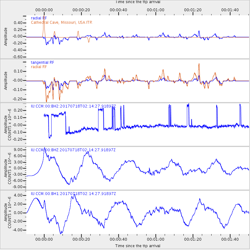
CCM Cathedral Cave, Missouri, USA - Earthquake Result Viewer
*The percent match for this event was below the threshold and hence no stack was calculated.
| Earthquake location: |
Near Coast Of Peru |
| Earthquake latitude/longitude: |
-16.4/-73.6 |
| Earthquake time(UTC): |
2017/07/18 (199) 02:05:19 GMT |
| Earthquake Depth: |
44 km |
| Earthquake Magnitude: |
6.4 Mww |
| Earthquake Catalog/Contributor: |
NEIC PDE/us |
|
| Network: |
IU Global Seismograph Network (GSN - IRIS/USGS) |
| Station: |
CCM Cathedral Cave, Missouri, USA |
| Lat/Lon: |
38.06 N/91.24 W |
| Elevation: |
222 m |
|
| Distance: |
56.6 deg |
| Az: |
343.357 deg |
| Baz: |
159.62 deg |
| Ray Param: |
$rayparam |
*The percent match for this event was below the threshold and hence was not used in the summary stack. |
|
| Radial Match: |
80.21659 % |
| Radial Bump: |
400 |
| Transverse Match: |
79.73866 % |
| Transverse Bump: |
400 |
| SOD ConfigId: |
2140511 |
| Insert Time: |
2017-07-31 18:00:49.002 +0000 |
| GWidth: |
2.5 |
| Max Bumps: |
400 |
| Tol: |
0.001 |
|
Signal To Noise
| Channel | StoN | STA | LTA |
| IU:CCM:00:BHZ:20170718T02:14:27.91897Z | 2.4349084 | 6.9736116E-6 | 2.8640138E-6 |
| IU:CCM:00:BH1:20170718T02:14:27.91897Z | 0.89573526 | 1.6403585E-6 | 1.8312984E-6 |
| IU:CCM:00:BH2:20170718T02:14:27.91897Z | 1.2803398 | 1.491012E-7 | 1.1645439E-7 |
| Arrivals |
| Ps | |
| PpPs | |
| PsPs/PpSs | |


