You are here: Home > Network List > US - United States National Seismic Network Stations List
> Station WUAZ Wupatki, Arizona, USA > Earthquake Result Viewer
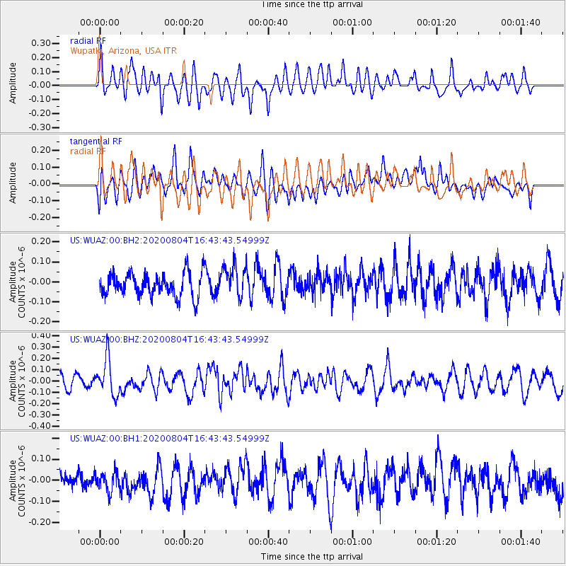
WUAZ Wupatki, Arizona, USA - Earthquake Result Viewer
*The percent match for this event was below the threshold and hence no stack was calculated.
| Earthquake location: |
Santa Cruz Islands |
| Earthquake latitude/longitude: |
-12.6/166.6 |
| Earthquake time(UTC): |
2020/08/04 (217) 16:31:19 GMT |
| Earthquake Depth: |
70 km |
| Earthquake Magnitude: |
5.6 mww |
| Earthquake Catalog/Contributor: |
NEIC PDE/us |
|
| Network: |
US United States National Seismic Network |
| Station: |
WUAZ Wupatki, Arizona, USA |
| Lat/Lon: |
35.52 N/111.37 W |
| Elevation: |
1592 m |
|
| Distance: |
90.8 deg |
| Az: |
53.899 deg |
| Baz: |
255.222 deg |
| Ray Param: |
$rayparam |
*The percent match for this event was below the threshold and hence was not used in the summary stack. |
|
| Radial Match: |
63.156063 % |
| Radial Bump: |
400 |
| Transverse Match: |
54.18546 % |
| Transverse Bump: |
400 |
| SOD ConfigId: |
21709731 |
| Insert Time: |
2020-08-18 16:49:01.935 +0000 |
| GWidth: |
2.5 |
| Max Bumps: |
400 |
| Tol: |
0.001 |
|
Signal To Noise
| Channel | StoN | STA | LTA |
| US:WUAZ:00:BHZ:20200804T16:43:43.54999Z | 2.8532913 | 1.6580448E-7 | 5.8109904E-8 |
| US:WUAZ:00:BH1:20200804T16:43:43.54999Z | 1.0415251 | 4.869505E-8 | 4.67536E-8 |
| US:WUAZ:00:BH2:20200804T16:43:43.54999Z | 1.437044 | 8.3368406E-8 | 5.801381E-8 |
| Arrivals |
| Ps | |
| PpPs | |
| PsPs/PpSs | |


