You are here: Home > Network List > AK - Alaska Regional Network Stations List
> Station BMR Bremner River > Earthquake Result Viewer
BMR Bremner River - Earthquake Result Viewer
| Earthquake location: |
Near Coast Of Guatemala |
| Earthquake latitude/longitude: |
13.4/-92.0 |
| Earthquake time(UTC): |
2020/08/04 (217) 19:17:52 GMT |
| Earthquake Depth: |
12 km |
| Earthquake Magnitude: |
5.8 mww |
| Earthquake Catalog/Contributor: |
NEIC PDE/us |
|
| Network: |
AK Alaska Regional Network |
| Station: |
BMR Bremner River |
| Lat/Lon: |
60.97 N/144.60 W |
| Elevation: |
842 m |
|
| Distance: |
60.8 deg |
| Az: |
333.617 deg |
| Baz: |
117.543 deg |
| Ray Param: |
0.061323836 |
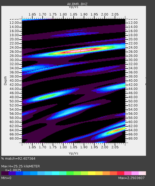
| Estimated Moho Depth: |
25.25 km |
| Estimated Crust Vp/Vs: |
1.88 |
| Assumed Crust Vp: |
6.566 km/s |
| Estimated Crust Vs: |
3.488 km/s |
| Estimated Crust Poisson's Ratio: |
0.30 |
|
| Radial Match: |
92.407364 % |
| Radial Bump: |
400 |
| Transverse Match: |
82.7684 % |
| Transverse Bump: |
400 |
| SOD ConfigId: |
21709731 |
| Insert Time: |
2020-08-18 19:19:43.599 +0000 |
| GWidth: |
2.5 |
| Max Bumps: |
400 |
| Tol: |
0.001 |
|

Signal To Noise
| Channel | StoN | STA | LTA |
| AK:BMR: :BHZ:20200804T19:27:33.107995Z | 15.945169 | 1.030292E-6 | 6.4614674E-8 |
| AK:BMR: :BHN:20200804T19:27:33.107995Z | 2.382671 | 2.2948616E-7 | 9.6314665E-8 |
| AK:BMR: :BHE:20200804T19:27:33.107995Z | 4.878635 | 4.316607E-7 | 8.8479815E-8 |
| Arrivals |
| Ps | 3.6 SECOND |
| PpPs | 11 SECOND |
| PsPs/PpSs | 14 SECOND |


