You are here: Home > Network List > TA - USArray Transportable Network (new EarthScope stations) Stations List
> Station POKR Poker Plat Research Range, AK, USA > Earthquake Result Viewer
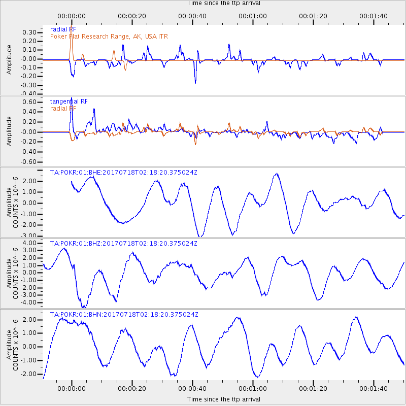
POKR Poker Plat Research Range, AK, USA - Earthquake Result Viewer
*The percent match for this event was below the threshold and hence no stack was calculated.
| Earthquake location: |
Near Coast Of Peru |
| Earthquake latitude/longitude: |
-16.4/-73.6 |
| Earthquake time(UTC): |
2017/07/18 (199) 02:05:19 GMT |
| Earthquake Depth: |
44 km |
| Earthquake Magnitude: |
6.4 Mww |
| Earthquake Catalog/Contributor: |
NEIC PDE/us |
|
| Network: |
TA USArray Transportable Network (new EarthScope stations) |
| Station: |
POKR Poker Plat Research Range, AK, USA |
| Lat/Lon: |
65.12 N/147.43 W |
| Elevation: |
501 m |
|
| Distance: |
98.1 deg |
| Az: |
335.766 deg |
| Baz: |
111.381 deg |
| Ray Param: |
$rayparam |
*The percent match for this event was below the threshold and hence was not used in the summary stack. |
|
| Radial Match: |
57.62236 % |
| Radial Bump: |
313 |
| Transverse Match: |
62.160343 % |
| Transverse Bump: |
400 |
| SOD ConfigId: |
2140511 |
| Insert Time: |
2017-07-31 18:02:30.764 +0000 |
| GWidth: |
2.5 |
| Max Bumps: |
400 |
| Tol: |
0.001 |
|
Signal To Noise
| Channel | StoN | STA | LTA |
| TA:POKR:01:BHZ:20170718T02:18:20.375024Z | 1.5328192 | 3.2238386E-6 | 2.1032088E-6 |
| TA:POKR:01:BHN:20170718T02:18:20.375024Z | 1.3467185 | 2.3464972E-6 | 1.7423814E-6 |
| TA:POKR:01:BHE:20170718T02:18:20.375024Z | 0.49929205 | 7.2287037E-7 | 1.4477907E-6 |
| Arrivals |
| Ps | |
| PpPs | |
| PsPs/PpSs | |


