You are here: Home > Network List > US - United States National Seismic Network Stations List
> Station MNTX Cornudas Mountains, Texas, USA > Earthquake Result Viewer
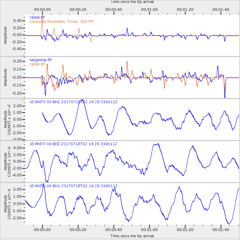
MNTX Cornudas Mountains, Texas, USA - Earthquake Result Viewer
*The percent match for this event was below the threshold and hence no stack was calculated.
| Earthquake location: |
Near Coast Of Peru |
| Earthquake latitude/longitude: |
-16.4/-73.6 |
| Earthquake time(UTC): |
2017/07/18 (199) 02:05:19 GMT |
| Earthquake Depth: |
44 km |
| Earthquake Magnitude: |
6.4 Mww |
| Earthquake Catalog/Contributor: |
NEIC PDE/us |
|
| Network: |
US United States National Seismic Network |
| Station: |
MNTX Cornudas Mountains, Texas, USA |
| Lat/Lon: |
31.70 N/105.38 W |
| Elevation: |
404 m |
|
| Distance: |
56.7 deg |
| Az: |
327.521 deg |
| Baz: |
142.796 deg |
| Ray Param: |
$rayparam |
*The percent match for this event was below the threshold and hence was not used in the summary stack. |
|
| Radial Match: |
73.52081 % |
| Radial Bump: |
400 |
| Transverse Match: |
48.31202 % |
| Transverse Bump: |
400 |
| SOD ConfigId: |
2140511 |
| Insert Time: |
2017-07-31 18:03:38.448 +0000 |
| GWidth: |
2.5 |
| Max Bumps: |
400 |
| Tol: |
0.001 |
|
Signal To Noise
| Channel | StoN | STA | LTA |
| US:MNTX:00:BHZ:20170718T02:14:28.399011Z | 3.496799 | 3.639546E-6 | 1.0408222E-6 |
| US:MNTX:00:BH1:20170718T02:14:28.399011Z | 1.7997099 | 1.5751923E-6 | 8.752479E-7 |
| US:MNTX:00:BH2:20170718T02:14:28.399011Z | 0.44190907 | 6.1967637E-7 | 1.4022712E-6 |
| Arrivals |
| Ps | |
| PpPs | |
| PsPs/PpSs | |


