You are here: Home > Network List > US - United States National Seismic Network Stations List
> Station VBMS Vicksburg, Mississippi > Earthquake Result Viewer
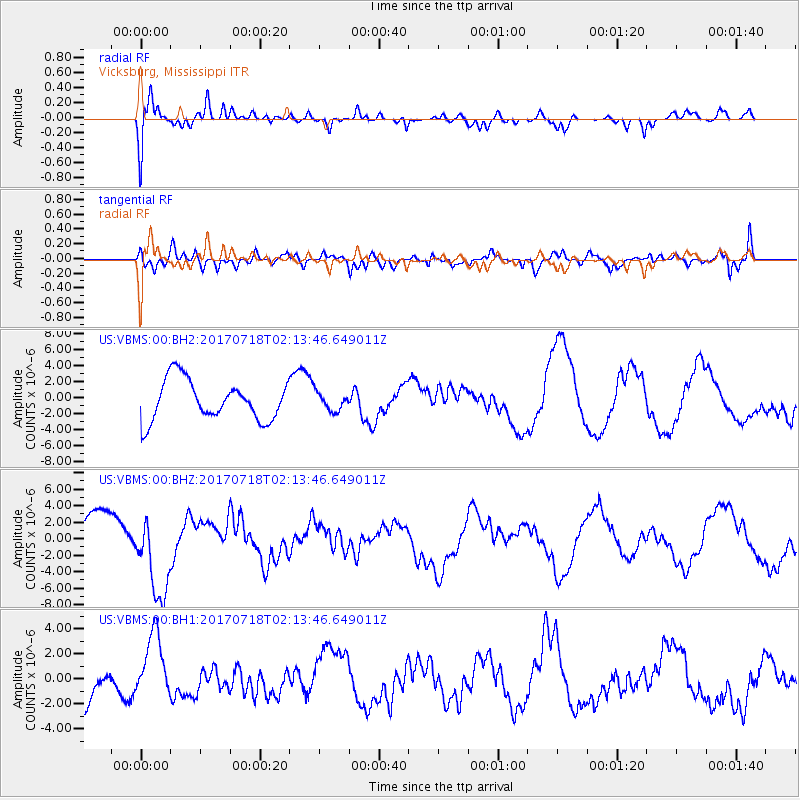
VBMS Vicksburg, Mississippi - Earthquake Result Viewer
*The percent match for this event was below the threshold and hence no stack was calculated.
| Earthquake location: |
Near Coast Of Peru |
| Earthquake latitude/longitude: |
-16.4/-73.6 |
| Earthquake time(UTC): |
2017/07/18 (199) 02:05:19 GMT |
| Earthquake Depth: |
44 km |
| Earthquake Magnitude: |
6.4 Mww |
| Earthquake Catalog/Contributor: |
NEIC PDE/us |
|
| Network: |
US United States National Seismic Network |
| Station: |
VBMS Vicksburg, Mississippi |
| Lat/Lon: |
32.22 N/90.52 W |
| Elevation: |
16 m |
|
| Distance: |
51.0 deg |
| Az: |
341.495 deg |
| Baz: |
158.937 deg |
| Ray Param: |
$rayparam |
*The percent match for this event was below the threshold and hence was not used in the summary stack. |
|
| Radial Match: |
60.248142 % |
| Radial Bump: |
400 |
| Transverse Match: |
51.002525 % |
| Transverse Bump: |
400 |
| SOD ConfigId: |
2140511 |
| Insert Time: |
2017-07-31 18:03:50.237 +0000 |
| GWidth: |
2.5 |
| Max Bumps: |
400 |
| Tol: |
0.001 |
|
Signal To Noise
| Channel | StoN | STA | LTA |
| US:VBMS:00:BHZ:20170718T02:13:46.649011Z | 2.2133868 | 5.1359093E-6 | 2.320385E-6 |
| US:VBMS:00:BH1:20170718T02:13:46.649011Z | 0.8131213 | 2.6371958E-6 | 3.2432995E-6 |
| US:VBMS:00:BH2:20170718T02:13:46.649011Z | 0.44338068 | 1.0997435E-6 | 2.4803594E-6 |
| Arrivals |
| Ps | |
| PpPs | |
| PsPs/PpSs | |


