You are here: Home > Network List > CI - Caltech Regional Seismic Network Stations List
> Station FMP Fort MacArthur Park, Pt. Fermin San Pedro, CA, USA > Earthquake Result Viewer
FMP Fort MacArthur Park, Pt. Fermin San Pedro, CA, USA - Earthquake Result Viewer
| Earthquake location: |
Near Coast Of Guatemala |
| Earthquake latitude/longitude: |
13.4/-92.0 |
| Earthquake time(UTC): |
2020/08/04 (217) 19:17:52 GMT |
| Earthquake Depth: |
12 km |
| Earthquake Magnitude: |
5.8 mww |
| Earthquake Catalog/Contributor: |
NEIC PDE/us |
|
| Network: |
CI Caltech Regional Seismic Network |
| Station: |
FMP Fort MacArthur Park, Pt. Fermin San Pedro, CA, USA |
| Lat/Lon: |
33.71 N/118.29 W |
| Elevation: |
89 m |
|
| Distance: |
31.4 deg |
| Az: |
314.721 deg |
| Baz: |
123.934 deg |
| Ray Param: |
0.079098165 |
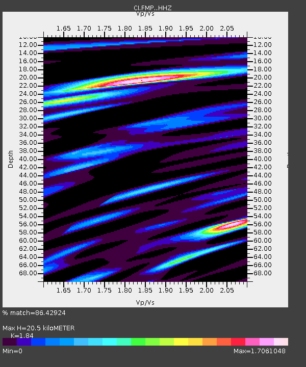
| Estimated Moho Depth: |
20.5 km |
| Estimated Crust Vp/Vs: |
1.84 |
| Assumed Crust Vp: |
6.048 km/s |
| Estimated Crust Vs: |
3.287 km/s |
| Estimated Crust Poisson's Ratio: |
0.29 |
|
| Radial Match: |
86.42924 % |
| Radial Bump: |
400 |
| Transverse Match: |
70.792465 % |
| Transverse Bump: |
400 |
| SOD ConfigId: |
21709731 |
| Insert Time: |
2020-08-18 19:28:25.281 +0000 |
| GWidth: |
2.5 |
| Max Bumps: |
400 |
| Tol: |
0.001 |
|
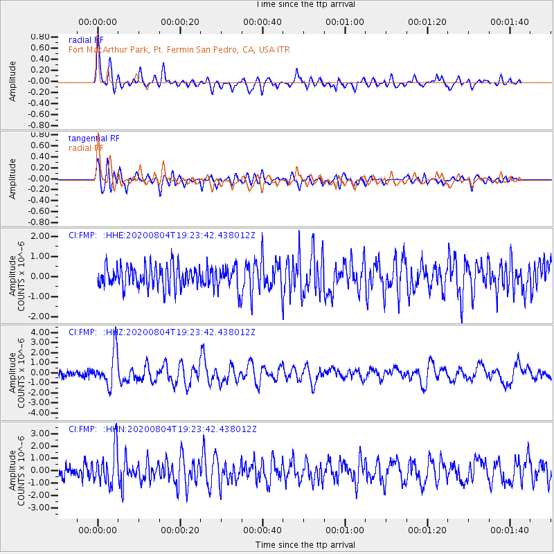
Signal To Noise
| Channel | StoN | STA | LTA |
| CI:FMP: :HHZ:20200804T19:23:42.438012Z | 8.122843 | 1.7641239E-6 | 2.171806E-7 |
| CI:FMP: :HHN:20200804T19:23:42.438012Z | 3.4761252 | 1.466311E-6 | 4.218234E-7 |
| CI:FMP: :HHE:20200804T19:23:42.438012Z | 1.2171518 | 6.352422E-7 | 5.2190876E-7 |
| Arrivals |
| Ps | 3.0 SECOND |
| PpPs | 9.0 SECOND |
| PsPs/PpSs | 12 SECOND |


