You are here: Home > Network List > CI - Caltech Regional Seismic Network Stations List
> Station GMR Granite Mountains Research Center > Earthquake Result Viewer
GMR Granite Mountains Research Center - Earthquake Result Viewer
| Earthquake location: |
Near Coast Of Guatemala |
| Earthquake latitude/longitude: |
13.4/-92.0 |
| Earthquake time(UTC): |
2020/08/04 (217) 19:17:52 GMT |
| Earthquake Depth: |
12 km |
| Earthquake Magnitude: |
5.8 mww |
| Earthquake Catalog/Contributor: |
NEIC PDE/us |
|
| Network: |
CI Caltech Regional Seismic Network |
| Station: |
GMR Granite Mountains Research Center |
| Lat/Lon: |
34.78 N/115.66 W |
| Elevation: |
1326 m |
|
| Distance: |
30.2 deg |
| Az: |
318.933 deg |
| Baz: |
129.028 deg |
| Ray Param: |
0.07947337 |
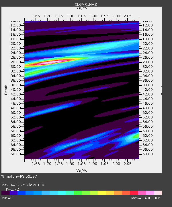
| Estimated Moho Depth: |
27.75 km |
| Estimated Crust Vp/Vs: |
1.72 |
| Assumed Crust Vp: |
6.276 km/s |
| Estimated Crust Vs: |
3.649 km/s |
| Estimated Crust Poisson's Ratio: |
0.24 |
|
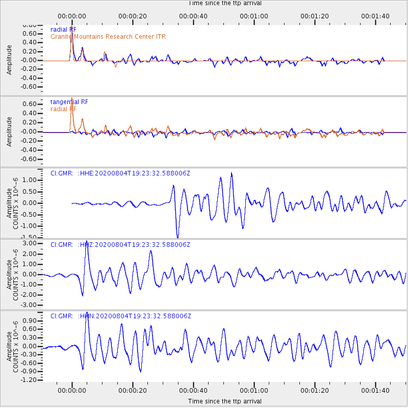
| Radial Match: |
93.50197 % |
| Radial Bump: |
301 |
| Transverse Match: |
83.74567 % |
| Transverse Bump: |
400 |
| SOD ConfigId: |
21709731 |
| Insert Time: |
2020-08-18 19:28:28.803 +0000 |
| GWidth: |
2.5 |
| Max Bumps: |
400 |
| Tol: |
0.001 |
|
Signal To Noise
| Channel | StoN | STA | LTA |
| CI:GMR: :HHZ:20200804T19:23:32.588006Z | 15.126415 | 1.199943E-6 | 7.932765E-8 |
| CI:GMR: :HHN:20200804T19:23:32.588006Z | 11.123945 | 4.3468046E-7 | 3.9076106E-8 |
| CI:GMR: :HHE:20200804T19:23:32.588006Z | 8.699004 | 4.9629506E-7 | 5.705194E-8 |
| Arrivals |
| Ps | 3.4 SECOND |
| PpPs | 11 SECOND |
| PsPs/PpSs | 15 SECOND |


