You are here: Home > Network List > CN - Canadian National Seismograph Network Stations List
> Station LMN Caledonia Mtn., NB, CA > Earthquake Result Viewer
LMN Caledonia Mtn., NB, CA - Earthquake Result Viewer
| Earthquake location: |
Near Coast Of Guatemala |
| Earthquake latitude/longitude: |
13.4/-92.0 |
| Earthquake time(UTC): |
2020/08/04 (217) 19:17:52 GMT |
| Earthquake Depth: |
12 km |
| Earthquake Magnitude: |
5.8 mww |
| Earthquake Catalog/Contributor: |
NEIC PDE/us |
|
| Network: |
CN Canadian National Seismograph Network |
| Station: |
LMN Caledonia Mtn., NB, CA |
| Lat/Lon: |
45.85 N/64.81 W |
| Elevation: |
365 m |
|
| Distance: |
39.7 deg |
| Az: |
29.95 deg |
| Baz: |
224.048 deg |
| Ray Param: |
0.074831136 |
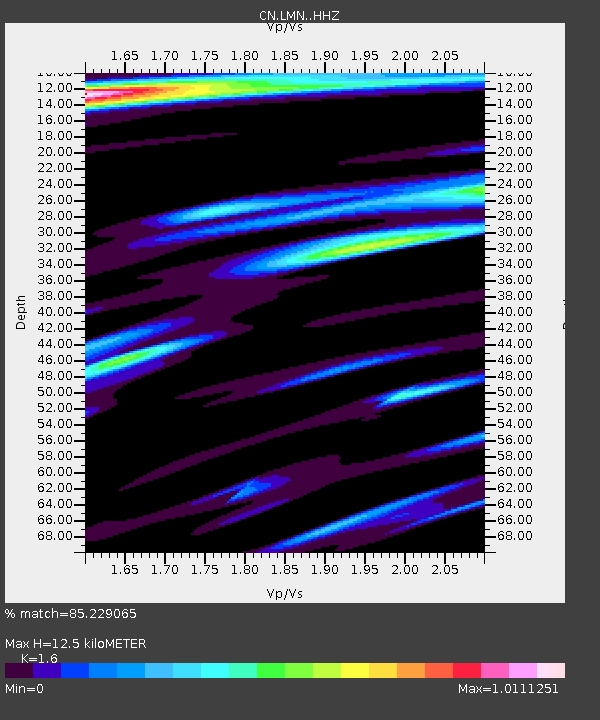
| Estimated Moho Depth: |
12.5 km |
| Estimated Crust Vp/Vs: |
1.60 |
| Assumed Crust Vp: |
6.419 km/s |
| Estimated Crust Vs: |
4.012 km/s |
| Estimated Crust Poisson's Ratio: |
0.18 |
|
| Radial Match: |
85.229065 % |
| Radial Bump: |
358 |
| Transverse Match: |
61.93431 % |
| Transverse Bump: |
392 |
| SOD ConfigId: |
21709731 |
| Insert Time: |
2020-08-18 19:30:51.505 +0000 |
| GWidth: |
2.5 |
| Max Bumps: |
400 |
| Tol: |
0.001 |
|

Signal To Noise
| Channel | StoN | STA | LTA |
| CN:LMN: :HHZ:20200804T19:24:53.770013Z | 3.7342546 | 1.0142533E-6 | 2.7160797E-7 |
| CN:LMN: :HHN:20200804T19:24:53.770013Z | 3.973431 | 5.756736E-7 | 1.4488073E-7 |
| CN:LMN: :HHE:20200804T19:24:53.770013Z | 1.8942124 | 3.7513735E-7 | 1.9804396E-7 |
| Arrivals |
| Ps | 1.3 SECOND |
| PpPs | 4.7 SECOND |
| PsPs/PpSs | 5.9 SECOND |


