You are here: Home > Network List > TX - Texas Seismological Network Stations List
> Station SN01 Snyder 1 > Earthquake Result Viewer
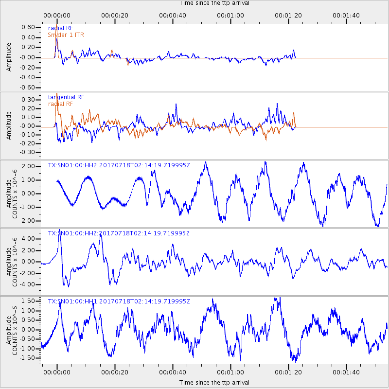
SN01 Snyder 1 - Earthquake Result Viewer
*The percent match for this event was below the threshold and hence no stack was calculated.
| Earthquake location: |
Near Coast Of Peru |
| Earthquake latitude/longitude: |
-16.4/-73.6 |
| Earthquake time(UTC): |
2017/07/18 (199) 02:05:19 GMT |
| Earthquake Depth: |
44 km |
| Earthquake Magnitude: |
6.4 Mww |
| Earthquake Catalog/Contributor: |
NEIC PDE/us |
|
| Network: |
TX Texas Seismological Network |
| Station: |
SN01 Snyder 1 |
| Lat/Lon: |
32.86 N/100.89 W |
| Elevation: |
717 m |
|
| Distance: |
55.5 deg |
| Az: |
332.084 deg |
| Baz: |
147.73 deg |
| Ray Param: |
$rayparam |
*The percent match for this event was below the threshold and hence was not used in the summary stack. |
|
| Radial Match: |
67.80274 % |
| Radial Bump: |
400 |
| Transverse Match: |
65.765495 % |
| Transverse Bump: |
398 |
| SOD ConfigId: |
2140511 |
| Insert Time: |
2017-07-31 18:05:30.091 +0000 |
| GWidth: |
2.5 |
| Max Bumps: |
400 |
| Tol: |
0.001 |
|
Signal To Noise
| Channel | StoN | STA | LTA |
| TX:SN01:00:HHZ:20170718T02:14:19.719995Z | 7.403822 | 3.1880202E-6 | 4.3059114E-7 |
| TX:SN01:00:HH1:20170718T02:14:19.719995Z | 0.7610978 | 7.396754E-7 | 9.718533E-7 |
| TX:SN01:00:HH2:20170718T02:14:19.719995Z | 1.5805401 | 1.1135938E-6 | 7.045654E-7 |
| Arrivals |
| Ps | |
| PpPs | |
| PsPs/PpSs | |


