You are here: Home > Network List > N4 - Central and EAstern US Network Stations List
> Station SPMN Marine on St. Croix, MN, USA > Earthquake Result Viewer
SPMN Marine on St. Croix, MN, USA - Earthquake Result Viewer
| Earthquake location: |
Near Coast Of Guatemala |
| Earthquake latitude/longitude: |
13.4/-92.0 |
| Earthquake time(UTC): |
2020/08/04 (217) 19:17:52 GMT |
| Earthquake Depth: |
12 km |
| Earthquake Magnitude: |
5.8 mww |
| Earthquake Catalog/Contributor: |
NEIC PDE/us |
|
| Network: |
N4 Central and EAstern US Network |
| Station: |
SPMN Marine on St. Croix, MN, USA |
| Lat/Lon: |
45.22 N/92.80 W |
| Elevation: |
311 m |
|
| Distance: |
31.8 deg |
| Az: |
358.857 deg |
| Baz: |
178.426 deg |
| Ray Param: |
0.07894272 |
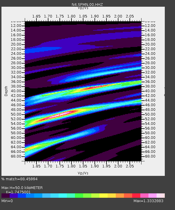
| Estimated Moho Depth: |
50.0 km |
| Estimated Crust Vp/Vs: |
1.75 |
| Assumed Crust Vp: |
6.571 km/s |
| Estimated Crust Vs: |
3.76 km/s |
| Estimated Crust Poisson's Ratio: |
0.26 |
|
| Radial Match: |
88.45994 % |
| Radial Bump: |
342 |
| Transverse Match: |
63.588238 % |
| Transverse Bump: |
400 |
| SOD ConfigId: |
21709731 |
| Insert Time: |
2020-08-18 19:36:17.137 +0000 |
| GWidth: |
2.5 |
| Max Bumps: |
400 |
| Tol: |
0.001 |
|

Signal To Noise
| Channel | StoN | STA | LTA |
| N4:SPMN:00:HHZ:20200804T19:23:45.989007Z | 4.802632 | 5.612172E-7 | 1.1685617E-7 |
| N4:SPMN:00:HH1:20200804T19:23:45.989007Z | 3.672131 | 5.232077E-7 | 1.4248066E-7 |
| N4:SPMN:00:HH2:20200804T19:23:45.989007Z | 1.2488508 | 1.7924314E-7 | 1.4352646E-7 |
| Arrivals |
| Ps | 6.2 SECOND |
| PpPs | 19 SECOND |
| PsPs/PpSs | 25 SECOND |


