You are here: Home > Network List > PO - Portable Observatories for Lithospheric Analysis and Research Investigating Seis Stations List
> Station NMSQ Nemaska Station, QC, CA > Earthquake Result Viewer
NMSQ Nemaska Station, QC, CA - Earthquake Result Viewer
| Earthquake location: |
Near Coast Of Guatemala |
| Earthquake latitude/longitude: |
13.4/-92.0 |
| Earthquake time(UTC): |
2020/08/04 (217) 19:17:52 GMT |
| Earthquake Depth: |
12 km |
| Earthquake Magnitude: |
5.8 mww |
| Earthquake Catalog/Contributor: |
NEIC PDE/us |
|
| Network: |
PO Portable Observatories for Lithospheric Analysis and Research Investigating Seis |
| Station: |
NMSQ Nemaska Station, QC, CA |
| Lat/Lon: |
51.71 N/76.02 W |
| Elevation: |
275 m |
|
| Distance: |
40.4 deg |
| Az: |
15.286 deg |
| Baz: |
204.359 deg |
| Ray Param: |
0.07444201 |
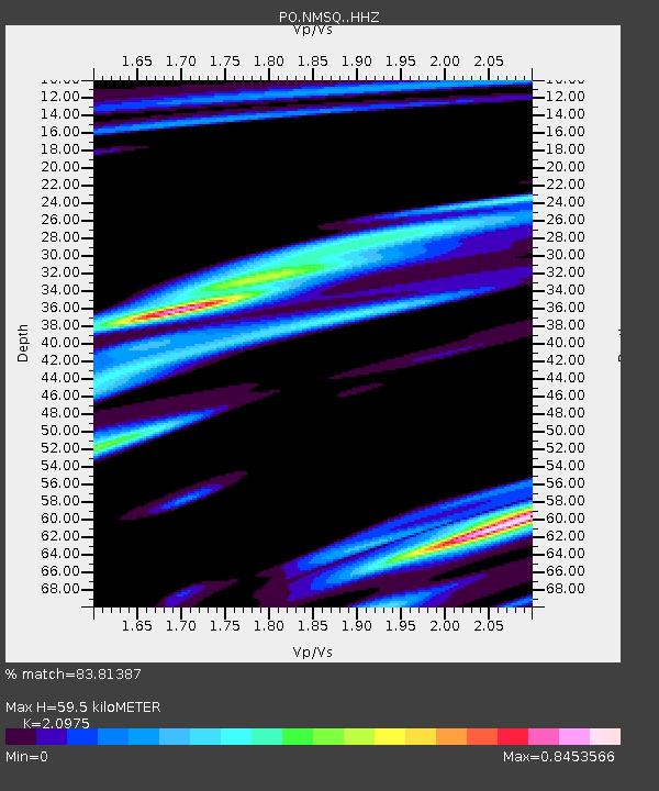
| Estimated Moho Depth: |
59.5 km |
| Estimated Crust Vp/Vs: |
2.10 |
| Assumed Crust Vp: |
6.459 km/s |
| Estimated Crust Vs: |
3.08 km/s |
| Estimated Crust Poisson's Ratio: |
0.35 |
|
| Radial Match: |
83.81387 % |
| Radial Bump: |
238 |
| Transverse Match: |
69.06066 % |
| Transverse Bump: |
400 |
| SOD ConfigId: |
21709731 |
| Insert Time: |
2020-08-18 19:38:19.352 +0000 |
| GWidth: |
2.5 |
| Max Bumps: |
400 |
| Tol: |
0.001 |
|

Signal To Noise
| Channel | StoN | STA | LTA |
| PO:NMSQ: :HHZ:20200804T19:24:59.286004Z | 1.8091067 | 7.845851E-7 | 4.3368647E-7 |
| PO:NMSQ: :HHN:20200804T19:24:59.286004Z | 1.586864 | 3.9937177E-7 | 2.5167358E-7 |
| PO:NMSQ: :HHE:20200804T19:24:59.286004Z | 1.6642699 | 2.1202715E-7 | 1.273995E-7 |
| Arrivals |
| Ps | 11 SECOND |
| PpPs | 27 SECOND |
| PsPs/PpSs | 38 SECOND |


