You are here: Home > Network List > TA - USArray Transportable Network (new EarthScope stations) Stations List
> Station D25K Kavik River, AK, USA > Earthquake Result Viewer
D25K Kavik River, AK, USA - Earthquake Result Viewer
| Earthquake location: |
Near Coast Of Guatemala |
| Earthquake latitude/longitude: |
13.4/-92.0 |
| Earthquake time(UTC): |
2020/08/04 (217) 19:17:52 GMT |
| Earthquake Depth: |
12 km |
| Earthquake Magnitude: |
5.8 mww |
| Earthquake Catalog/Contributor: |
NEIC PDE/us |
|
| Network: |
TA USArray Transportable Network (new EarthScope stations) |
| Station: |
D25K Kavik River, AK, USA |
| Lat/Lon: |
69.32 N/146.38 W |
| Elevation: |
770 m |
|
| Distance: |
65.4 deg |
| Az: |
341.48 deg |
| Baz: |
119.497 deg |
| Ray Param: |
0.058266755 |
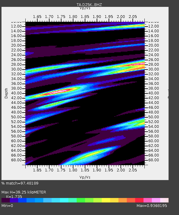
| Estimated Moho Depth: |
39.25 km |
| Estimated Crust Vp/Vs: |
1.74 |
| Assumed Crust Vp: |
6.378 km/s |
| Estimated Crust Vs: |
3.676 km/s |
| Estimated Crust Poisson's Ratio: |
0.25 |
|
| Radial Match: |
97.48189 % |
| Radial Bump: |
400 |
| Transverse Match: |
94.94253 % |
| Transverse Bump: |
400 |
| SOD ConfigId: |
21709731 |
| Insert Time: |
2020-08-18 19:39:55.686 +0000 |
| GWidth: |
2.5 |
| Max Bumps: |
400 |
| Tol: |
0.001 |
|
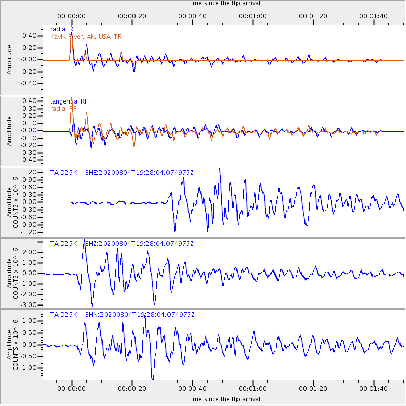
Signal To Noise
| Channel | StoN | STA | LTA |
| TA:D25K: :BHZ:20200804T19:28:04.074975Z | 33.478485 | 1.2977267E-6 | 3.8763005E-8 |
| TA:D25K: :BHN:20200804T19:28:04.074975Z | 8.979647 | 3.4994534E-7 | 3.897095E-8 |
| TA:D25K: :BHE:20200804T19:28:04.074975Z | 14.881328 | 4.1242683E-7 | 2.7714382E-8 |
| Arrivals |
| Ps | 4.7 SECOND |
| PpPs | 16 SECOND |
| PsPs/PpSs | 21 SECOND |


