You are here: Home > Network List > TA - USArray Transportable Network (new EarthScope stations) Stations List
> Station O17K Koliganek, Bristol Bay, AK, USA > Earthquake Result Viewer
O17K Koliganek, Bristol Bay, AK, USA - Earthquake Result Viewer
| Earthquake location: |
Near Coast Of Guatemala |
| Earthquake latitude/longitude: |
13.4/-92.0 |
| Earthquake time(UTC): |
2020/08/04 (217) 19:17:52 GMT |
| Earthquake Depth: |
12 km |
| Earthquake Magnitude: |
5.8 mww |
| Earthquake Catalog/Contributor: |
NEIC PDE/us |
|
| Network: |
TA USArray Transportable Network (new EarthScope stations) |
| Station: |
O17K Koliganek, Bristol Bay, AK, USA |
| Lat/Lon: |
59.77 N/157.09 W |
| Elevation: |
156 m |
|
| Distance: |
66.1 deg |
| Az: |
329.862 deg |
| Baz: |
105.01 deg |
| Ray Param: |
0.057829972 |
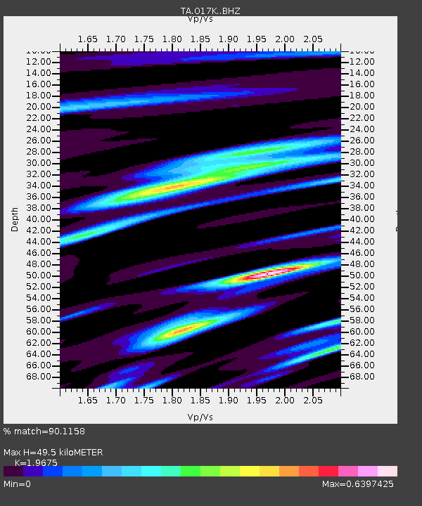
| Estimated Moho Depth: |
49.5 km |
| Estimated Crust Vp/Vs: |
1.97 |
| Assumed Crust Vp: |
6.276 km/s |
| Estimated Crust Vs: |
3.19 km/s |
| Estimated Crust Poisson's Ratio: |
0.33 |
|
| Radial Match: |
90.1158 % |
| Radial Bump: |
382 |
| Transverse Match: |
69.93797 % |
| Transverse Bump: |
400 |
| SOD ConfigId: |
21709731 |
| Insert Time: |
2020-08-18 19:42:06.058 +0000 |
| GWidth: |
2.5 |
| Max Bumps: |
400 |
| Tol: |
0.001 |
|
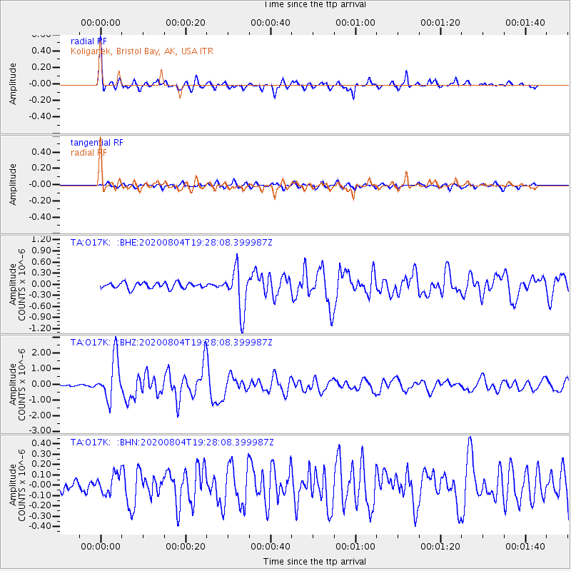
Signal To Noise
| Channel | StoN | STA | LTA |
| TA:O17K: :BHZ:20200804T19:28:08.399987Z | 17.37572 | 1.3576137E-6 | 7.81328E-8 |
| TA:O17K: :BHN:20200804T19:28:08.399987Z | 1.0751605 | 9.698365E-8 | 9.020388E-8 |
| TA:O17K: :BHE:20200804T19:28:08.399987Z | 7.571558 | 5.883711E-7 | 7.7708066E-8 |
| Arrivals |
| Ps | 7.9 SECOND |
| PpPs | 23 SECOND |
| PsPs/PpSs | 31 SECOND |


