You are here: Home > Network List > TA - USArray Transportable Network (new EarthScope stations) Stations List
> Station O28M Mount Upton, YT, CAN > Earthquake Result Viewer
O28M Mount Upton, YT, CAN - Earthquake Result Viewer

| Earthquake location: |
Near Coast Of Guatemala |
| Earthquake latitude/longitude: |
13.4/-92.0 |
| Earthquake time(UTC): |
2020/08/04 (217) 19:17:52 GMT |
| Earthquake Depth: |
12 km |
| Earthquake Magnitude: |
5.8 mww |
| Earthquake Catalog/Contributor: |
NEIC PDE/us |
|
| Network: |
TA USArray Transportable Network (new EarthScope stations) |
| Station: |
O28M Mount Upton, YT, CAN |
| Lat/Lon: |
60.77 N/140.19 W |
| Elevation: |
2622 m |
|
| Distance: |
58.8 deg |
| Az: |
334.658 deg |
| Baz: |
121.916 deg |
| Ray Param: |
0.06260612 |
| Estimated Moho Depth: |
42.75 km |
| Estimated Crust Vp/Vs: |
1.76 |
| Assumed Crust Vp: |
6.566 km/s |
| Estimated Crust Vs: |
3.725 km/s |
| Estimated Crust Poisson's Ratio: |
0.26 |
|
| Radial Match: |
93.60079 % |
| Radial Bump: |
400 |
| Transverse Match: |
89.65146 % |
| Transverse Bump: |
387 |
| SOD ConfigId: |
21709731 |
| Insert Time: |
2020-08-18 19:42:08.402 +0000 |
| GWidth: |
2.5 |
| Max Bumps: |
400 |
| Tol: |
0.001 |
|
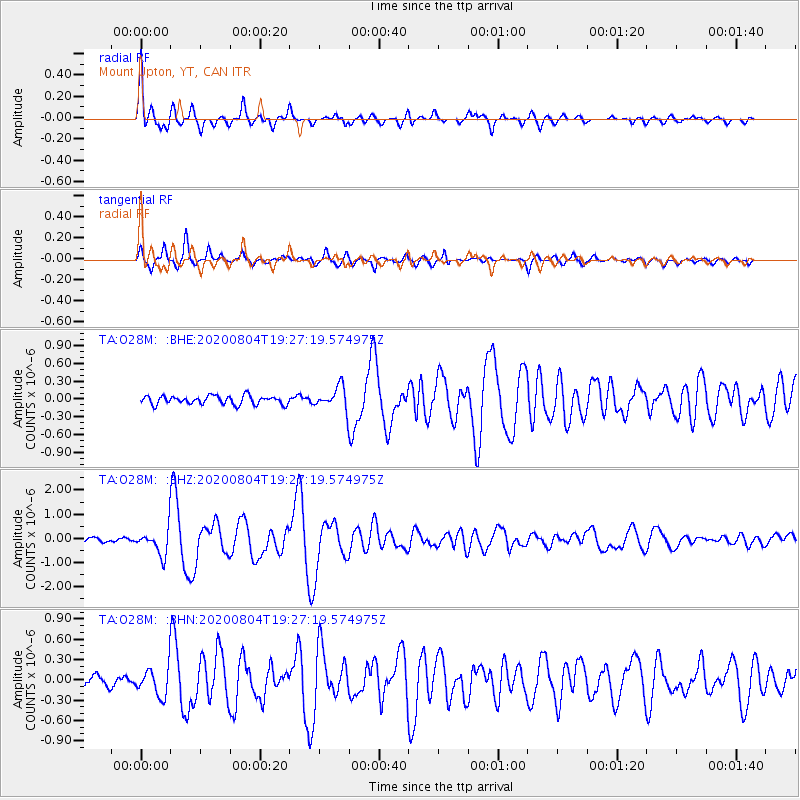
Signal To Noise
| Channel | StoN | STA | LTA |
| TA:O28M: :BHZ:20200804T19:27:19.574975Z | 7.29705 | 5.3531676E-7 | 7.336071E-8 |
| TA:O28M: :BHN:20200804T19:27:19.574975Z | 2.591478 | 2.0918729E-7 | 8.072123E-8 |
| TA:O28M: :BHE:20200804T19:27:19.574975Z | 2.6793826 | 1.9325581E-7 | 7.2127E-8 |
| Arrivals |
| Ps | 5.2 SECOND |
| PpPs | 17 SECOND |
| PsPs/PpSs | 22 SECOND |


