You are here: Home > Network List > TA - USArray Transportable Network (new EarthScope stations) Stations List
> Station P33M Teslin, Yukon, CA > Earthquake Result Viewer
P33M Teslin, Yukon, CA - Earthquake Result Viewer
| Earthquake location: |
Near Coast Of Guatemala |
| Earthquake latitude/longitude: |
13.4/-92.0 |
| Earthquake time(UTC): |
2020/08/04 (217) 19:17:52 GMT |
| Earthquake Depth: |
12 km |
| Earthquake Magnitude: |
5.8 mww |
| Earthquake Catalog/Contributor: |
NEIC PDE/us |
|
| Network: |
TA USArray Transportable Network (new EarthScope stations) |
| Station: |
P33M Teslin, Yukon, CA |
| Lat/Lon: |
60.21 N/132.82 W |
| Elevation: |
1066 m |
|
| Distance: |
55.5 deg |
| Az: |
336.647 deg |
| Baz: |
129.404 deg |
| Ray Param: |
0.06474358 |
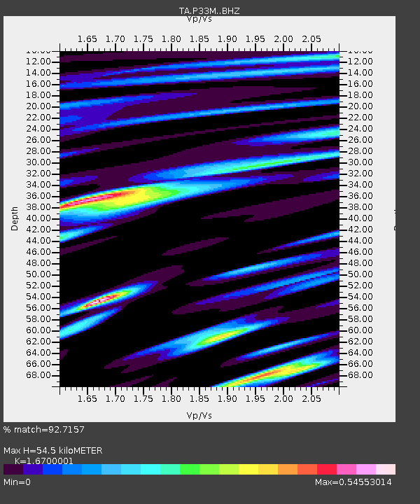
| Estimated Moho Depth: |
54.5 km |
| Estimated Crust Vp/Vs: |
1.67 |
| Assumed Crust Vp: |
6.419 km/s |
| Estimated Crust Vs: |
3.844 km/s |
| Estimated Crust Poisson's Ratio: |
0.22 |
|
| Radial Match: |
92.7157 % |
| Radial Bump: |
360 |
| Transverse Match: |
76.83787 % |
| Transverse Bump: |
400 |
| SOD ConfigId: |
21709731 |
| Insert Time: |
2020-08-18 19:42:16.486 +0000 |
| GWidth: |
2.5 |
| Max Bumps: |
400 |
| Tol: |
0.001 |
|

Signal To Noise
| Channel | StoN | STA | LTA |
| TA:P33M: :BHZ:20200804T19:26:56.324975Z | 15.320312 | 9.772713E-7 | 6.378926E-8 |
| TA:P33M: :BHN:20200804T19:26:56.324975Z | 5.8847923 | 3.9458305E-7 | 6.705132E-8 |
| TA:P33M: :BHE:20200804T19:26:56.324975Z | 6.4432726 | 3.9439797E-7 | 6.121082E-8 |
| Arrivals |
| Ps | 6.0 SECOND |
| PpPs | 21 SECOND |
| PsPs/PpSs | 27 SECOND |


