You are here: Home > Network List > TA - USArray Transportable Network (new EarthScope stations) Stations List
> Station S34M Telegraph Creek, BC, CAN > Earthquake Result Viewer
S34M Telegraph Creek, BC, CAN - Earthquake Result Viewer
| Earthquake location: |
Near Coast Of Guatemala |
| Earthquake latitude/longitude: |
13.4/-92.0 |
| Earthquake time(UTC): |
2020/08/04 (217) 19:17:52 GMT |
| Earthquake Depth: |
12 km |
| Earthquake Magnitude: |
5.8 mww |
| Earthquake Catalog/Contributor: |
NEIC PDE/us |
|
| Network: |
TA USArray Transportable Network (new EarthScope stations) |
| Station: |
S34M Telegraph Creek, BC, CAN |
| Lat/Lon: |
57.91 N/131.13 W |
| Elevation: |
298 m |
|
| Distance: |
53.4 deg |
| Az: |
335.15 deg |
| Baz: |
129.977 deg |
| Ray Param: |
0.06616111 |
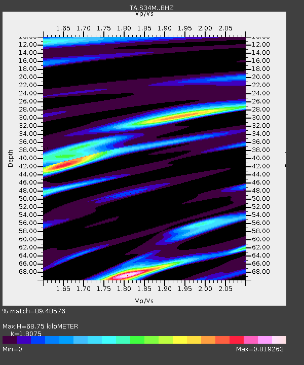
| Estimated Moho Depth: |
68.75 km |
| Estimated Crust Vp/Vs: |
1.81 |
| Assumed Crust Vp: |
6.597 km/s |
| Estimated Crust Vs: |
3.65 km/s |
| Estimated Crust Poisson's Ratio: |
0.28 |
|
| Radial Match: |
89.48576 % |
| Radial Bump: |
331 |
| Transverse Match: |
78.23927 % |
| Transverse Bump: |
400 |
| SOD ConfigId: |
21709731 |
| Insert Time: |
2020-08-18 19:42:21.831 +0000 |
| GWidth: |
2.5 |
| Max Bumps: |
400 |
| Tol: |
0.001 |
|

Signal To Noise
| Channel | StoN | STA | LTA |
| TA:S34M: :BHZ:20200804T19:26:40.774987Z | 6.6556373 | 5.027393E-7 | 7.553586E-8 |
| TA:S34M: :BHN:20200804T19:26:40.774987Z | 2.8636 | 1.5200011E-7 | 5.3080075E-8 |
| TA:S34M: :BHE:20200804T19:26:40.774987Z | 2.1367903 | 1.7291576E-7 | 8.092313E-8 |
| Arrivals |
| Ps | 8.9 SECOND |
| PpPs | 28 SECOND |
| PsPs/PpSs | 37 SECOND |


