You are here: Home > Network List > UO - University of Oregon Regional Network Stations List
> Station WOOD Lake of the Woods, OR, USA > Earthquake Result Viewer
WOOD Lake of the Woods, OR, USA - Earthquake Result Viewer
| Earthquake location: |
Near Coast Of Guatemala |
| Earthquake latitude/longitude: |
13.4/-92.0 |
| Earthquake time(UTC): |
2020/08/04 (217) 19:17:52 GMT |
| Earthquake Depth: |
12 km |
| Earthquake Magnitude: |
5.8 mww |
| Earthquake Catalog/Contributor: |
NEIC PDE/us |
|
| Network: |
UO University of Oregon Regional Network |
| Station: |
WOOD Lake of the Woods, OR, USA |
| Lat/Lon: |
42.22 N/122.30 W |
| Elevation: |
1437 m |
|
| Distance: |
39.0 deg |
| Az: |
323.35 deg |
| Baz: |
128.543 deg |
| Ray Param: |
0.07527883 |
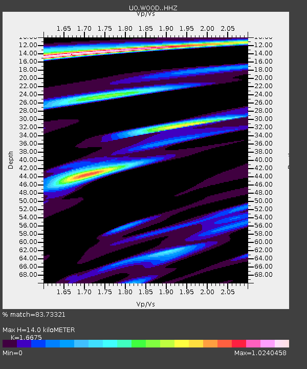
| Estimated Moho Depth: |
14.0 km |
| Estimated Crust Vp/Vs: |
1.67 |
| Assumed Crust Vp: |
6.522 km/s |
| Estimated Crust Vs: |
3.911 km/s |
| Estimated Crust Poisson's Ratio: |
0.22 |
|
| Radial Match: |
83.73321 % |
| Radial Bump: |
324 |
| Transverse Match: |
74.62644 % |
| Transverse Bump: |
400 |
| SOD ConfigId: |
21709731 |
| Insert Time: |
2020-08-18 19:43:19.073 +0000 |
| GWidth: |
2.5 |
| Max Bumps: |
400 |
| Tol: |
0.001 |
|

Signal To Noise
| Channel | StoN | STA | LTA |
| UO:WOOD: :HHZ:20200804T19:24:47.658013Z | 26.696728 | 2.162052E-6 | 8.098565E-8 |
| UO:WOOD: :HHN:20200804T19:24:47.658013Z | 6.0800033 | 6.3286774E-7 | 1.04090034E-7 |
| UO:WOOD: :HHE:20200804T19:24:47.658013Z | 5.536651 | 6.797316E-7 | 1.2276945E-7 |
| Arrivals |
| Ps | 1.6 SECOND |
| PpPs | 5.3 SECOND |
| PsPs/PpSs | 6.8 SECOND |


