You are here: Home > Network List > UO - University of Oregon Regional Network Stations List
> Station SALT Butte Falls, OR, USA > Earthquake Result Viewer
SALT Butte Falls, OR, USA - Earthquake Result Viewer
| Earthquake location: |
Near Coast Of Guatemala |
| Earthquake latitude/longitude: |
13.4/-92.0 |
| Earthquake time(UTC): |
2020/08/04 (217) 19:17:52 GMT |
| Earthquake Depth: |
12 km |
| Earthquake Magnitude: |
5.8 mww |
| Earthquake Catalog/Contributor: |
NEIC PDE/us |
|
| Network: |
UO University of Oregon Regional Network |
| Station: |
SALT Butte Falls, OR, USA |
| Lat/Lon: |
42.49 N/122.59 W |
| Elevation: |
1179 m |
|
| Distance: |
39.3 deg |
| Az: |
323.483 deg |
| Baz: |
128.456 deg |
| Ray Param: |
0.07507521 |
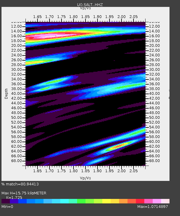
| Estimated Moho Depth: |
15.75 km |
| Estimated Crust Vp/Vs: |
1.73 |
| Assumed Crust Vp: |
6.522 km/s |
| Estimated Crust Vs: |
3.781 km/s |
| Estimated Crust Poisson's Ratio: |
0.25 |
|
| Radial Match: |
80.94413 % |
| Radial Bump: |
286 |
| Transverse Match: |
68.91085 % |
| Transverse Bump: |
400 |
| SOD ConfigId: |
21709731 |
| Insert Time: |
2020-08-18 19:43:29.590 +0000 |
| GWidth: |
2.5 |
| Max Bumps: |
400 |
| Tol: |
0.001 |
|

Signal To Noise
| Channel | StoN | STA | LTA |
| UO:SALT: :HHZ:20200804T19:24:50.469995Z | 12.395494 | 1.6254672E-6 | 1.3113372E-7 |
| UO:SALT: :HHN:20200804T19:24:50.469995Z | 2.970289 | 4.1720506E-7 | 1.4045942E-7 |
| UO:SALT: :HHE:20200804T19:24:50.469995Z | 4.4390187 | 5.891952E-7 | 1.3273096E-7 |
| Arrivals |
| Ps | 1.9 SECOND |
| PpPs | 6.1 SECOND |
| PsPs/PpSs | 8.0 SECOND |


