You are here: Home > Network List > US - United States National Seismic Network Stations List
> Station ERPA Erie, Pennsylvania, USA > Earthquake Result Viewer
ERPA Erie, Pennsylvania, USA - Earthquake Result Viewer
| Earthquake location: |
Near Coast Of Guatemala |
| Earthquake latitude/longitude: |
13.4/-92.0 |
| Earthquake time(UTC): |
2020/08/04 (217) 19:17:52 GMT |
| Earthquake Depth: |
12 km |
| Earthquake Magnitude: |
5.8 mww |
| Earthquake Catalog/Contributor: |
NEIC PDE/us |
|
| Network: |
US United States National Seismic Network |
| Station: |
ERPA Erie, Pennsylvania, USA |
| Lat/Lon: |
42.12 N/79.99 W |
| Elevation: |
306 m |
|
| Distance: |
30.5 deg |
| Az: |
17.697 deg |
| Baz: |
203.433 deg |
| Ray Param: |
0.07940443 |
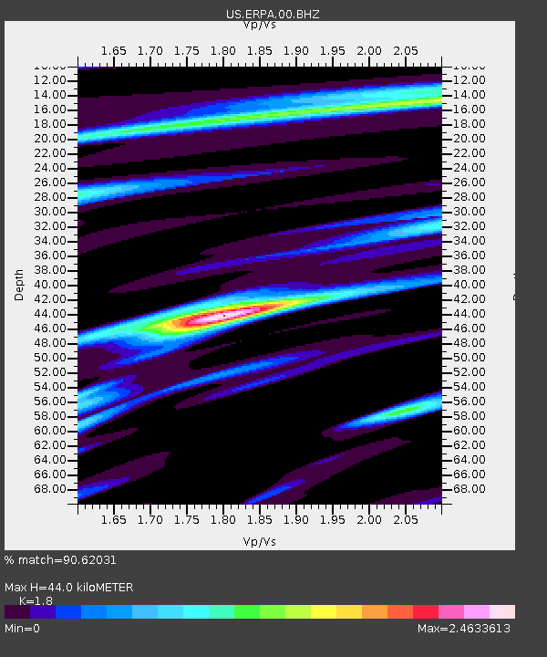
| Estimated Moho Depth: |
44.0 km |
| Estimated Crust Vp/Vs: |
1.80 |
| Assumed Crust Vp: |
6.419 km/s |
| Estimated Crust Vs: |
3.566 km/s |
| Estimated Crust Poisson's Ratio: |
0.28 |
|
| Radial Match: |
90.62031 % |
| Radial Bump: |
384 |
| Transverse Match: |
54.407364 % |
| Transverse Bump: |
400 |
| SOD ConfigId: |
21709731 |
| Insert Time: |
2020-08-18 19:43:45.232 +0000 |
| GWidth: |
2.5 |
| Max Bumps: |
400 |
| Tol: |
0.001 |
|

Signal To Noise
| Channel | StoN | STA | LTA |
| US:ERPA:00:BHZ:20200804T19:23:34.675012Z | 8.795839 | 4.988629E-7 | 5.6715784E-8 |
| US:ERPA:00:BH1:20200804T19:23:34.675012Z | 4.712719 | 6.348003E-7 | 1.3469938E-7 |
| US:ERPA:00:BH2:20200804T19:23:34.675012Z | 1.6376411 | 2.88002E-7 | 1.7586395E-7 |
| Arrivals |
| Ps | 5.9 SECOND |
| PpPs | 18 SECOND |
| PsPs/PpSs | 24 SECOND |


