You are here: Home > Network List > UU - University of Utah Regional Network Stations List
> Station SPU South Promontory Point, UT, USA > Earthquake Result Viewer
SPU South Promontory Point, UT, USA - Earthquake Result Viewer
| Earthquake location: |
Near Coast Of Guatemala |
| Earthquake latitude/longitude: |
13.4/-92.0 |
| Earthquake time(UTC): |
2020/08/04 (217) 19:17:52 GMT |
| Earthquake Depth: |
12 km |
| Earthquake Magnitude: |
5.8 mww |
| Earthquake Catalog/Contributor: |
NEIC PDE/us |
|
| Network: |
UU University of Utah Regional Network |
| Station: |
SPU South Promontory Point, UT, USA |
| Lat/Lon: |
41.31 N/112.45 W |
| Elevation: |
2086 m |
|
| Distance: |
33.1 deg |
| Az: |
331.113 deg |
| Baz: |
141.382 deg |
| Ray Param: |
0.07836093 |
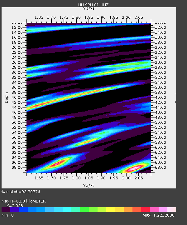
| Estimated Moho Depth: |
68.0 km |
| Estimated Crust Vp/Vs: |
2.04 |
| Assumed Crust Vp: |
6.276 km/s |
| Estimated Crust Vs: |
3.084 km/s |
| Estimated Crust Poisson's Ratio: |
0.34 |
|
| Radial Match: |
93.39776 % |
| Radial Bump: |
326 |
| Transverse Match: |
80.59249 % |
| Transverse Bump: |
400 |
| SOD ConfigId: |
21709731 |
| Insert Time: |
2020-08-18 19:44:47.941 +0000 |
| GWidth: |
2.5 |
| Max Bumps: |
400 |
| Tol: |
0.001 |
|

Signal To Noise
| Channel | StoN | STA | LTA |
| UU:SPU:01:HHZ:20200804T19:23:57.554986Z | 21.235281 | 2.9514275E-8 | 1.3898698E-9 |
| UU:SPU:01:HHN:20200804T19:23:57.554986Z | 6.0062747 | 1.1911339E-8 | 1.983149E-9 |
| UU:SPU:01:HHE:20200804T19:23:57.554986Z | 4.118735 | 8.790023E-9 | 2.134156E-9 |
| Arrivals |
| Ps | 12 SECOND |
| PpPs | 31 SECOND |
| PsPs/PpSs | 43 SECOND |


