You are here: Home > Network List > UU - University of Utah Regional Network Stations List
> Station SZCU Shurtz Canyon, UT, USA > Earthquake Result Viewer
SZCU Shurtz Canyon, UT, USA - Earthquake Result Viewer
| Earthquake location: |
Near Coast Of Guatemala |
| Earthquake latitude/longitude: |
13.4/-92.0 |
| Earthquake time(UTC): |
2020/08/04 (217) 19:17:52 GMT |
| Earthquake Depth: |
12 km |
| Earthquake Magnitude: |
5.8 mww |
| Earthquake Catalog/Contributor: |
NEIC PDE/us |
|
| Network: |
UU University of Utah Regional Network |
| Station: |
SZCU Shurtz Canyon, UT, USA |
| Lat/Lon: |
37.60 N/113.09 W |
| Elevation: |
2026 m |
|
| Distance: |
30.6 deg |
| Az: |
325.79 deg |
| Baz: |
136.455 deg |
| Ray Param: |
0.07936082 |
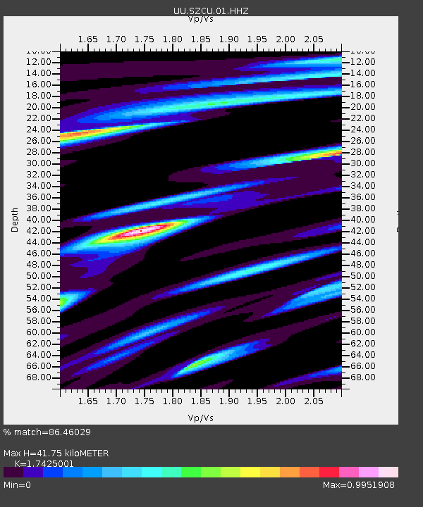
| Estimated Moho Depth: |
41.75 km |
| Estimated Crust Vp/Vs: |
1.74 |
| Assumed Crust Vp: |
6.194 km/s |
| Estimated Crust Vs: |
3.555 km/s |
| Estimated Crust Poisson's Ratio: |
0.25 |
|
| Radial Match: |
86.46029 % |
| Radial Bump: |
265 |
| Transverse Match: |
81.19346 % |
| Transverse Bump: |
334 |
| SOD ConfigId: |
21709731 |
| Insert Time: |
2020-08-18 19:44:53.453 +0000 |
| GWidth: |
2.5 |
| Max Bumps: |
400 |
| Tol: |
0.001 |
|

Signal To Noise
| Channel | StoN | STA | LTA |
| UU:SZCU:01:HHZ:20200804T19:23:35.890008Z | 10.386598 | 2.2548733E-8 | 2.1709452E-9 |
| UU:SZCU:01:HHN:20200804T19:23:35.890008Z | 3.1628346 | 7.957655E-9 | 2.5159885E-9 |
| UU:SZCU:01:HHE:20200804T19:23:35.890008Z | 4.851442 | 7.801137E-9 | 1.6080037E-9 |
| Arrivals |
| Ps | 5.4 SECOND |
| PpPs | 17 SECOND |
| PsPs/PpSs | 23 SECOND |


