You are here: Home > Network List > UW - Pacific Northwest Regional Seismic Network Stations List
> Station BLOW BLOW, Detroit Lake, OR, USA > Earthquake Result Viewer
BLOW BLOW, Detroit Lake, OR, USA - Earthquake Result Viewer

| Earthquake location: |
Near Coast Of Guatemala |
| Earthquake latitude/longitude: |
13.4/-92.0 |
| Earthquake time(UTC): |
2020/08/04 (217) 19:17:52 GMT |
| Earthquake Depth: |
12 km |
| Earthquake Magnitude: |
5.8 mww |
| Earthquake Catalog/Contributor: |
NEIC PDE/us |
|
| Network: |
UW Pacific Northwest Regional Seismic Network |
| Station: |
BLOW BLOW, Detroit Lake, OR, USA |
| Lat/Lon: |
44.68 N/122.19 W |
| Elevation: |
657 m |
|
| Distance: |
40.5 deg |
| Az: |
326.401 deg |
| Baz: |
130.972 deg |
| Ray Param: |
0.074377336 |
| Estimated Moho Depth: |
69.75 km |
| Estimated Crust Vp/Vs: |
1.68 |
| Assumed Crust Vp: |
6.566 km/s |
| Estimated Crust Vs: |
3.903 km/s |
| Estimated Crust Poisson's Ratio: |
0.23 |
|
| Radial Match: |
91.03031 % |
| Radial Bump: |
369 |
| Transverse Match: |
89.28481 % |
| Transverse Bump: |
400 |
| SOD ConfigId: |
21709731 |
| Insert Time: |
2020-08-18 19:45:06.363 +0000 |
| GWidth: |
2.5 |
| Max Bumps: |
400 |
| Tol: |
0.001 |
|
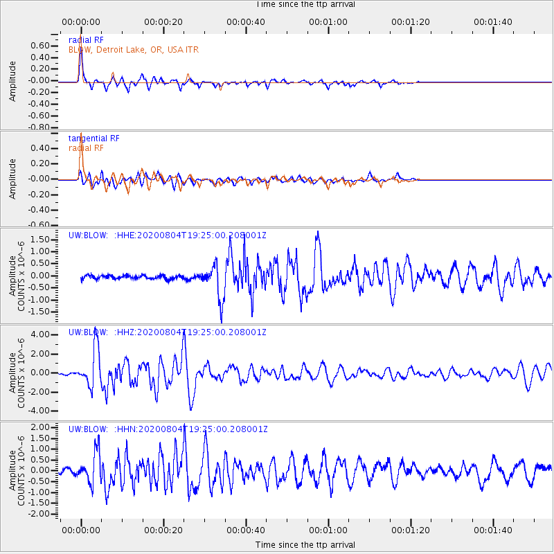
Signal To Noise
| Channel | StoN | STA | LTA |
| UW:BLOW: :HHZ:20200804T19:25:00.208001Z | 20.835976 | 2.067699E-6 | 9.9236956E-8 |
| UW:BLOW: :HHN:20200804T19:25:00.208001Z | 8.483537 | 7.281163E-7 | 8.5826976E-8 |
| UW:BLOW: :HHE:20200804T19:25:00.208001Z | 9.488962 | 7.190633E-7 | 7.5778914E-8 |
| Arrivals |
| Ps | 7.8 SECOND |
| PpPs | 26 SECOND |
| PsPs/PpSs | 34 SECOND |


