You are here: Home > Network List > UW - Pacific Northwest Regional Seismic Network Stations List
> Station HOOD Mt Hood Meadows, OR CREST BB SMO > Earthquake Result Viewer
HOOD Mt Hood Meadows, OR CREST BB SMO - Earthquake Result Viewer
| Earthquake location: |
Near Coast Of Guatemala |
| Earthquake latitude/longitude: |
13.4/-92.0 |
| Earthquake time(UTC): |
2020/08/04 (217) 19:17:52 GMT |
| Earthquake Depth: |
12 km |
| Earthquake Magnitude: |
5.8 mww |
| Earthquake Catalog/Contributor: |
NEIC PDE/us |
|
| Network: |
UW Pacific Northwest Regional Seismic Network |
| Station: |
HOOD Mt Hood Meadows, OR CREST BB SMO |
| Lat/Lon: |
45.32 N/121.65 W |
| Elevation: |
1520 m |
|
| Distance: |
40.6 deg |
| Az: |
327.521 deg |
| Baz: |
132.198 deg |
| Ray Param: |
0.07429409 |
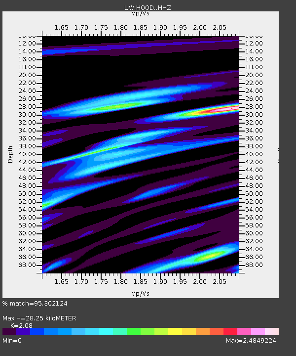
| Estimated Moho Depth: |
28.25 km |
| Estimated Crust Vp/Vs: |
2.08 |
| Assumed Crust Vp: |
6.597 km/s |
| Estimated Crust Vs: |
3.172 km/s |
| Estimated Crust Poisson's Ratio: |
0.35 |
|
| Radial Match: |
95.302124 % |
| Radial Bump: |
400 |
| Transverse Match: |
89.15187 % |
| Transverse Bump: |
400 |
| SOD ConfigId: |
21709731 |
| Insert Time: |
2020-08-18 19:45:31.678 +0000 |
| GWidth: |
2.5 |
| Max Bumps: |
400 |
| Tol: |
0.001 |
|
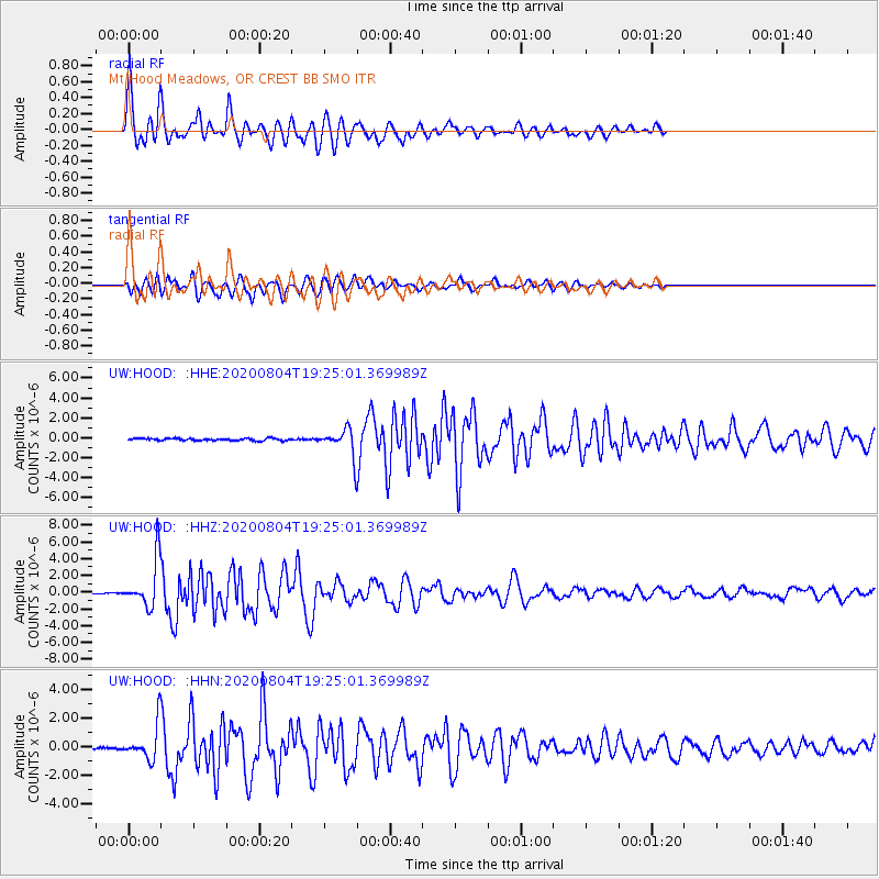
Signal To Noise
| Channel | StoN | STA | LTA |
| UW:HOOD: :HHZ:20200804T19:25:01.369989Z | 50.70987 | 2.8028533E-6 | 5.527234E-8 |
| UW:HOOD: :HHN:20200804T19:25:01.369989Z | 13.426648 | 1.1465256E-6 | 8.539179E-8 |
| UW:HOOD: :HHE:20200804T19:25:01.369989Z | 11.633701 | 1.2616177E-6 | 1.08445086E-7 |
| Arrivals |
| Ps | 4.9 SECOND |
| PpPs | 12 SECOND |
| PsPs/PpSs | 17 SECOND |


