You are here: Home > Network List > UW - Pacific Northwest Regional Seismic Network Stations List
> Station LUMI Lummi Island, WA > Earthquake Result Viewer
LUMI Lummi Island, WA - Earthquake Result Viewer
| Earthquake location: |
Near Coast Of Guatemala |
| Earthquake latitude/longitude: |
13.4/-92.0 |
| Earthquake time(UTC): |
2020/08/04 (217) 19:17:52 GMT |
| Earthquake Depth: |
12 km |
| Earthquake Magnitude: |
5.8 mww |
| Earthquake Catalog/Contributor: |
NEIC PDE/us |
|
| Network: |
UW Pacific Northwest Regional Seismic Network |
| Station: |
LUMI Lummi Island, WA |
| Lat/Lon: |
48.72 N/122.71 W |
| Elevation: |
19 m |
|
| Distance: |
43.5 deg |
| Az: |
330.506 deg |
| Baz: |
133.648 deg |
| Ray Param: |
0.07253533 |
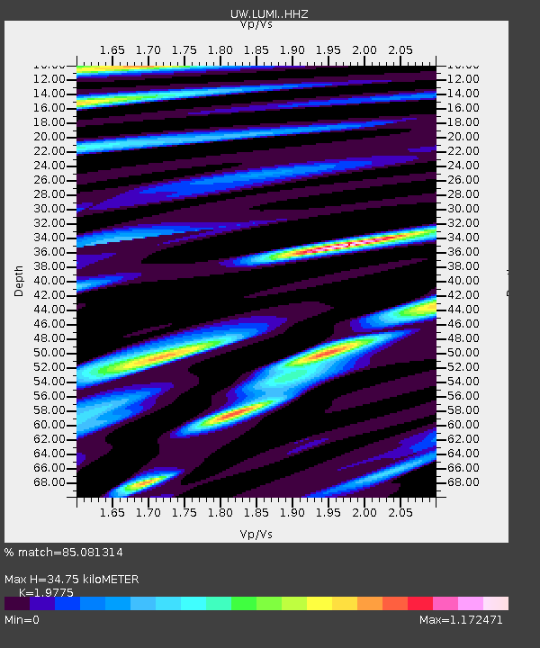
| Estimated Moho Depth: |
34.75 km |
| Estimated Crust Vp/Vs: |
1.98 |
| Assumed Crust Vp: |
6.566 km/s |
| Estimated Crust Vs: |
3.32 km/s |
| Estimated Crust Poisson's Ratio: |
0.33 |
|
| Radial Match: |
85.081314 % |
| Radial Bump: |
400 |
| Transverse Match: |
76.69471 % |
| Transverse Bump: |
400 |
| SOD ConfigId: |
21709731 |
| Insert Time: |
2020-08-18 19:45:50.574 +0000 |
| GWidth: |
2.5 |
| Max Bumps: |
400 |
| Tol: |
0.001 |
|

Signal To Noise
| Channel | StoN | STA | LTA |
| UW:LUMI: :HHZ:20200804T19:25:24.559991Z | 18.760498 | 1.9171841E-6 | 1.021926E-7 |
| UW:LUMI: :HHN:20200804T19:25:24.559991Z | 5.6346774 | 7.251514E-7 | 1.2869438E-7 |
| UW:LUMI: :HHE:20200804T19:25:24.559991Z | 6.7559557 | 8.298767E-7 | 1.2283631E-7 |
| Arrivals |
| Ps | 5.5 SECOND |
| PpPs | 15 SECOND |
| PsPs/PpSs | 20 SECOND |


