You are here: Home > Network List > GS - US Geological Survey Networks Stations List
> Station KAN08 Pence Farm, Harper, KS, USA > Earthquake Result Viewer
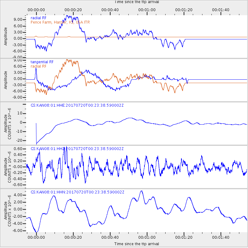
KAN08 Pence Farm, Harper, KS, USA - Earthquake Result Viewer
*The percent match for this event was below the threshold and hence no stack was calculated.
| Earthquake location: |
Near East Coast Of Honshu, Japan |
| Earthquake latitude/longitude: |
37.4/141.6 |
| Earthquake time(UTC): |
2017/07/20 (201) 00:11:25 GMT |
| Earthquake Depth: |
35 km |
| Earthquake Magnitude: |
5.8 Mww |
| Earthquake Catalog/Contributor: |
NEIC PDE/us |
|
| Network: |
GS US Geological Survey Networks |
| Station: |
KAN08 Pence Farm, Harper, KS, USA |
| Lat/Lon: |
37.23 N/97.97 W |
| Elevation: |
375 m |
|
| Distance: |
87.6 deg |
| Az: |
43.538 deg |
| Baz: |
316.604 deg |
| Ray Param: |
$rayparam |
*The percent match for this event was below the threshold and hence was not used in the summary stack. |
|
| Radial Match: |
27.394855 % |
| Radial Bump: |
400 |
| Transverse Match: |
51.6977 % |
| Transverse Bump: |
400 |
| SOD ConfigId: |
2140511 |
| Insert Time: |
2017-08-02 16:04:14.803 +0000 |
| GWidth: |
2.5 |
| Max Bumps: |
400 |
| Tol: |
0.001 |
|
Signal To Noise
| Channel | StoN | STA | LTA |
| GS:KAN08:01:HHZ:20170720T00:23:38.590002Z | 2.8533485 | 3.2383446E-7 | 1.1349278E-7 |
| GS:KAN08:01:HHN:20170720T00:23:38.590002Z | 1.4717828 | 7.891174E-6 | 5.3616436E-6 |
| GS:KAN08:01:HHE:20170720T00:23:38.590002Z | 0.34275898 | 2.816822E-6 | 8.218084E-6 |
| Arrivals |
| Ps | |
| PpPs | |
| PsPs/PpSs | |


