You are here: Home > Network List > AK - Alaska Regional Network Stations List
> Station GRNC Granite Creek, AK, USA > Earthquake Result Viewer
GRNC Granite Creek, AK, USA - Earthquake Result Viewer
| Earthquake location: |
Vanuatu Islands |
| Earthquake latitude/longitude: |
-16.1/168.1 |
| Earthquake time(UTC): |
2020/08/05 (218) 12:05:36 GMT |
| Earthquake Depth: |
175 km |
| Earthquake Magnitude: |
6.4 mww |
| Earthquake Catalog/Contributor: |
NEIC PDE/us |
|
| Network: |
AK Alaska Regional Network |
| Station: |
GRNC Granite Creek, AK, USA |
| Lat/Lon: |
60.73 N/141.76 W |
| Elevation: |
2116 m |
|
| Distance: |
86.4 deg |
| Az: |
22.214 deg |
| Baz: |
227.691 deg |
| Ray Param: |
0.043660488 |
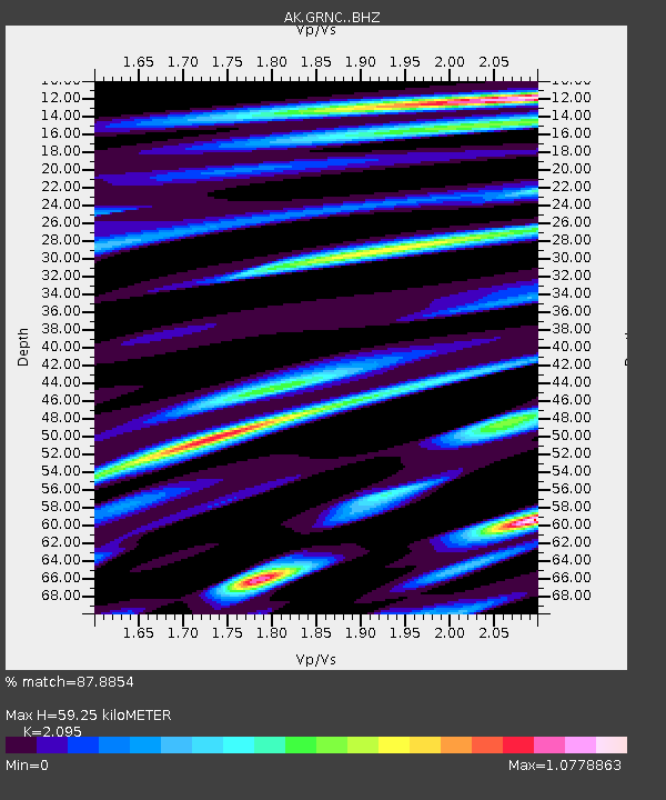
| Estimated Moho Depth: |
59.25 km |
| Estimated Crust Vp/Vs: |
2.10 |
| Assumed Crust Vp: |
6.566 km/s |
| Estimated Crust Vs: |
3.134 km/s |
| Estimated Crust Poisson's Ratio: |
0.35 |
|
| Radial Match: |
87.8854 % |
| Radial Bump: |
400 |
| Transverse Match: |
79.10921 % |
| Transverse Bump: |
400 |
| SOD ConfigId: |
21709731 |
| Insert Time: |
2020-08-19 12:07:31.378 +0000 |
| GWidth: |
2.5 |
| Max Bumps: |
400 |
| Tol: |
0.001 |
|

Signal To Noise
| Channel | StoN | STA | LTA |
| AK:GRNC: :BHZ:20200805T12:17:27.727976Z | 9.680996 | 7.2852976E-7 | 7.5253595E-8 |
| AK:GRNC: :BHN:20200805T12:17:27.727976Z | 1.6696744 | 1.913226E-7 | 1.14586776E-7 |
| AK:GRNC: :BHE:20200805T12:17:27.727976Z | 2.0458343 | 2.1695264E-7 | 1.06046045E-7 |
| Arrivals |
| Ps | 10 SECOND |
| PpPs | 27 SECOND |
| PsPs/PpSs | 37 SECOND |


