You are here: Home > Network List > XC00 - Yellowstone Intermountain Seismic Array Stations List
> Station Y07 Y07 > Earthquake Result Viewer
Y07 Y07 - Earthquake Result Viewer
| Earthquake location: |
Tonga Islands |
| Earthquake latitude/longitude: |
-15.9/-173.7 |
| Earthquake time(UTC): |
2000/09/11 (255) 17:17:53 GMT |
| Earthquake Depth: |
115 km |
| Earthquake Magnitude: |
6.0 MB, 6.3 MW, 6.3 MW |
| Earthquake Catalog/Contributor: |
WHDF/NEIC |
|
| Network: |
XC Yellowstone Intermountain Seismic Array |
| Station: |
Y07 Y07 |
| Lat/Lon: |
42.56 N/110.89 W |
| Elevation: |
2155 m |
|
| Distance: |
81.9 deg |
| Az: |
41.596 deg |
| Baz: |
239.847 deg |
| Ray Param: |
0.04703515 |
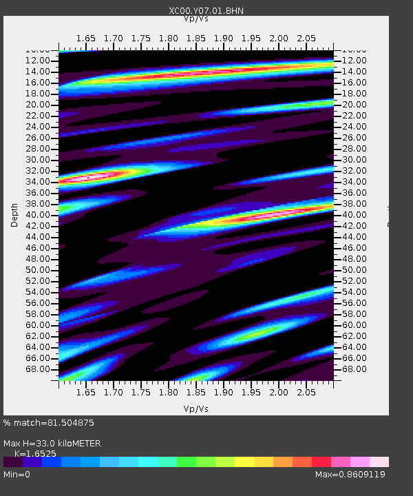
| Estimated Moho Depth: |
33.0 km |
| Estimated Crust Vp/Vs: |
1.65 |
| Assumed Crust Vp: |
6.207 km/s |
| Estimated Crust Vs: |
3.756 km/s |
| Estimated Crust Poisson's Ratio: |
0.21 |
|
| Radial Match: |
81.504875 % |
| Radial Bump: |
400 |
| Transverse Match: |
80.14633 % |
| Transverse Bump: |
400 |
| SOD ConfigId: |
16820 |
| Insert Time: |
2010-02-26 15:00:49.882 +0000 |
| GWidth: |
2.5 |
| Max Bumps: |
400 |
| Tol: |
0.001 |
|

Signal To Noise
| Channel | StoN | STA | LTA |
| XC:Y07:01:BHN:20000911T17:29:28.728003Z | 4.7958636 | 1.0904816E-6 | 2.2737963E-7 |
| XC:Y07:01:BHE:20000911T17:29:28.728003Z | 2.6933072 | 9.537683E-7 | 3.5412535E-7 |
| XC:Y07:01:BHZ:20000911T17:29:28.728003Z | 12.842718 | 4.19584E-6 | 3.2670968E-7 |
| Arrivals |
| Ps | 3.6 SECOND |
| PpPs | 14 SECOND |
| PsPs/PpSs | 17 SECOND |


