You are here: Home > Network List > AK - Alaska Regional Network Stations List
> Station MDM Murphy Dome > Earthquake Result Viewer
MDM Murphy Dome - Earthquake Result Viewer
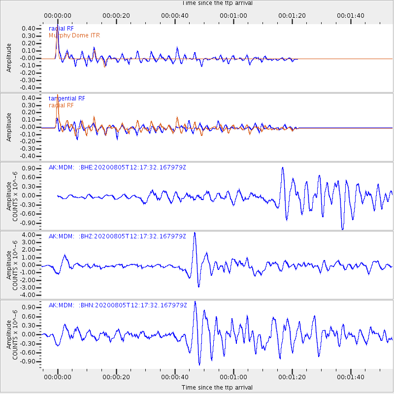
| Earthquake location: |
Vanuatu Islands |
| Earthquake latitude/longitude: |
-16.1/168.1 |
| Earthquake time(UTC): |
2020/08/05 (218) 12:05:36 GMT |
| Earthquake Depth: |
175 km |
| Earthquake Magnitude: |
6.4 mww |
| Earthquake Catalog/Contributor: |
NEIC PDE/us |
|
| Network: |
AK Alaska Regional Network |
| Station: |
MDM Murphy Dome |
| Lat/Lon: |
64.96 N/148.23 W |
| Elevation: |
634 m |
|
| Distance: |
87.3 deg |
| Az: |
17.116 deg |
| Baz: |
221.657 deg |
| Ray Param: |
0.04299324 |
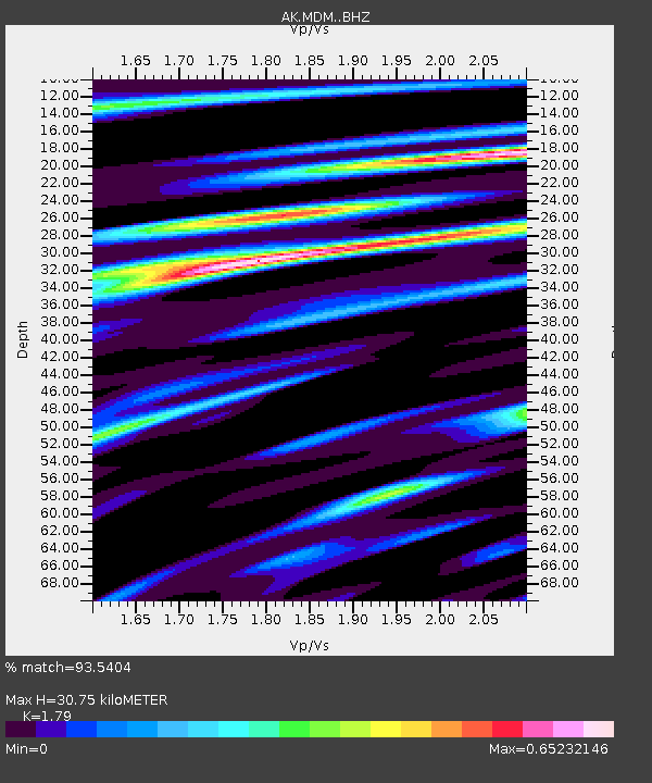
| Estimated Moho Depth: |
30.75 km |
| Estimated Crust Vp/Vs: |
1.79 |
| Assumed Crust Vp: |
6.566 km/s |
| Estimated Crust Vs: |
3.668 km/s |
| Estimated Crust Poisson's Ratio: |
0.27 |
|
| Radial Match: |
93.5404 % |
| Radial Bump: |
270 |
| Transverse Match: |
90.89462 % |
| Transverse Bump: |
380 |
| SOD ConfigId: |
21709731 |
| Insert Time: |
2020-08-19 12:08:21.791 +0000 |
| GWidth: |
2.5 |
| Max Bumps: |
400 |
| Tol: |
0.001 |
|
Signal To Noise
| Channel | StoN | STA | LTA |
| AK:MDM: :BHZ:20200805T12:17:32.167979Z | 18.058907 | 8.1450935E-7 | 4.510292E-8 |
| AK:MDM: :BHN:20200805T12:17:32.167979Z | 4.331714 | 2.2670571E-7 | 5.2336254E-8 |
| AK:MDM: :BHE:20200805T12:17:32.167979Z | 3.0758944 | 1.3514102E-7 | 4.3935522E-8 |
| Arrivals |
| Ps | 3.8 SECOND |
| PpPs | 13 SECOND |
| PsPs/PpSs | 17 SECOND |


