You are here: Home > Network List > AK - Alaska Regional Network Stations List
> Station O19K Port Alsworth, AK, USA > Earthquake Result Viewer
O19K Port Alsworth, AK, USA - Earthquake Result Viewer
| Earthquake location: |
Vanuatu Islands |
| Earthquake latitude/longitude: |
-16.1/168.1 |
| Earthquake time(UTC): |
2020/08/05 (218) 12:05:36 GMT |
| Earthquake Depth: |
175 km |
| Earthquake Magnitude: |
6.4 mww |
| Earthquake Catalog/Contributor: |
NEIC PDE/us |
|
| Network: |
AK Alaska Regional Network |
| Station: |
O19K Port Alsworth, AK, USA |
| Lat/Lon: |
60.20 N/154.32 W |
| Elevation: |
96 m |
|
| Distance: |
81.9 deg |
| Az: |
17.932 deg |
| Baz: |
216.329 deg |
| Ray Param: |
0.04686978 |
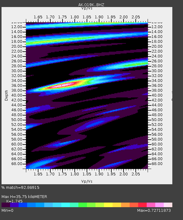
| Estimated Moho Depth: |
35.75 km |
| Estimated Crust Vp/Vs: |
1.75 |
| Assumed Crust Vp: |
6.566 km/s |
| Estimated Crust Vs: |
3.763 km/s |
| Estimated Crust Poisson's Ratio: |
0.26 |
|
| Radial Match: |
92.86915 % |
| Radial Bump: |
312 |
| Transverse Match: |
82.31307 % |
| Transverse Bump: |
308 |
| SOD ConfigId: |
21709731 |
| Insert Time: |
2020-08-19 12:08:29.591 +0000 |
| GWidth: |
2.5 |
| Max Bumps: |
400 |
| Tol: |
0.001 |
|

Signal To Noise
| Channel | StoN | STA | LTA |
| AK:O19K: :BHZ:20200805T12:17:04.820017Z | 8.93916 | 1.5291331E-6 | 1.7106004E-7 |
| AK:O19K: :BHN:20200805T12:17:04.820017Z | 3.3258197 | 4.44227E-7 | 1.3356917E-7 |
| AK:O19K: :BHE:20200805T12:17:04.820017Z | 1.3176587 | 2.678128E-7 | 2.03249E-7 |
| Arrivals |
| Ps | 4.2 SECOND |
| PpPs | 15 SECOND |
| PsPs/PpSs | 19 SECOND |


