You are here: Home > Network List > AK - Alaska Regional Network Stations List
> Station YAH Yahtse, AK, USA > Earthquake Result Viewer
YAH Yahtse, AK, USA - Earthquake Result Viewer
| Earthquake location: |
Vanuatu Islands |
| Earthquake latitude/longitude: |
-16.1/168.1 |
| Earthquake time(UTC): |
2020/08/05 (218) 12:05:36 GMT |
| Earthquake Depth: |
175 km |
| Earthquake Magnitude: |
6.4 mww |
| Earthquake Catalog/Contributor: |
NEIC PDE/us |
|
| Network: |
AK Alaska Regional Network |
| Station: |
YAH Yahtse, AK, USA |
| Lat/Lon: |
60.36 N/141.75 W |
| Elevation: |
2125 m |
|
| Distance: |
86.2 deg |
| Az: |
22.493 deg |
| Baz: |
227.713 deg |
| Ray Param: |
0.043842144 |
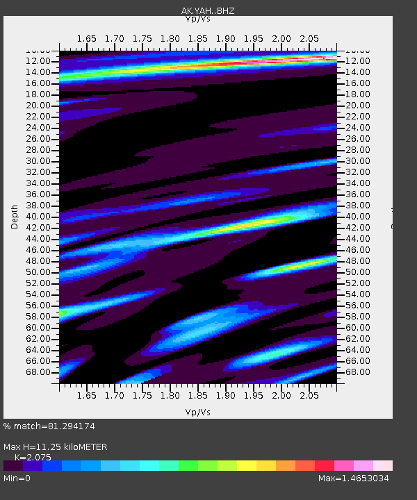
| Estimated Moho Depth: |
11.25 km |
| Estimated Crust Vp/Vs: |
2.08 |
| Assumed Crust Vp: |
6.566 km/s |
| Estimated Crust Vs: |
3.164 km/s |
| Estimated Crust Poisson's Ratio: |
0.35 |
|
| Radial Match: |
81.294174 % |
| Radial Bump: |
368 |
| Transverse Match: |
83.85037 % |
| Transverse Bump: |
350 |
| SOD ConfigId: |
21709731 |
| Insert Time: |
2020-08-19 12:09:27.928 +0000 |
| GWidth: |
2.5 |
| Max Bumps: |
400 |
| Tol: |
0.001 |
|

Signal To Noise
| Channel | StoN | STA | LTA |
| AK:YAH: :BHZ:20200805T12:17:26.508005Z | 4.6837926 | 9.693725E-7 | 2.0696315E-7 |
| AK:YAH: :BHN:20200805T12:17:26.508005Z | 0.7917703 | 1.5846227E-7 | 2.0013667E-7 |
| AK:YAH: :BHE:20200805T12:17:26.508005Z | 1.6516677 | 3.074833E-7 | 1.8616535E-7 |
| Arrivals |
| Ps | 1.9 SECOND |
| PpPs | 5.2 SECOND |
| PsPs/PpSs | 7.0 SECOND |


