You are here: Home > Network List > AK - Alaska Regional Network Stations List
> Station PS10 TAPS Pump Station 10, AK, USA > Earthquake Result Viewer
PS10 TAPS Pump Station 10, AK, USA - Earthquake Result Viewer
| Earthquake location: |
Vanuatu Islands |
| Earthquake latitude/longitude: |
-16.1/168.1 |
| Earthquake time(UTC): |
2020/08/05 (218) 12:05:36 GMT |
| Earthquake Depth: |
175 km |
| Earthquake Magnitude: |
6.4 mww |
| Earthquake Catalog/Contributor: |
NEIC PDE/us |
|
| Network: |
AK Alaska Regional Network |
| Station: |
PS10 TAPS Pump Station 10, AK, USA |
| Lat/Lon: |
63.42 N/145.77 W |
| Elevation: |
738 m |
|
| Distance: |
86.9 deg |
| Az: |
18.956 deg |
| Baz: |
223.961 deg |
| Ray Param: |
0.043283135 |
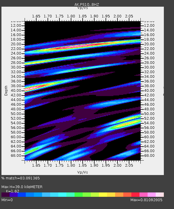
| Estimated Moho Depth: |
39.0 km |
| Estimated Crust Vp/Vs: |
1.62 |
| Assumed Crust Vp: |
6.566 km/s |
| Estimated Crust Vs: |
4.053 km/s |
| Estimated Crust Poisson's Ratio: |
0.19 |
|
| Radial Match: |
83.891365 % |
| Radial Bump: |
400 |
| Transverse Match: |
77.20277 % |
| Transverse Bump: |
400 |
| SOD ConfigId: |
21709731 |
| Insert Time: |
2020-08-19 12:09:38.984 +0000 |
| GWidth: |
2.5 |
| Max Bumps: |
400 |
| Tol: |
0.001 |
|

Signal To Noise
| Channel | StoN | STA | LTA |
| AK:PS10: :BHZ:20200805T12:17:30.268015Z | 2.681482 | 1.8114403E-6 | 6.7553697E-7 |
| AK:PS10: :BHN:20200805T12:17:30.268015Z | 2.9770293 | 3.8845715E-7 | 1.3048484E-7 |
| AK:PS10: :BHE:20200805T12:17:30.268015Z | 1.5097237 | 1.8821437E-7 | 1.2466809E-7 |
| Arrivals |
| Ps | 3.8 SECOND |
| PpPs | 15 SECOND |
| PsPs/PpSs | 19 SECOND |


