You are here: Home > Network List > AV - Alaska Volcano Observatory Stations List
> Station Q17K Contact Creek, Katmai, AK, USA > Earthquake Result Viewer
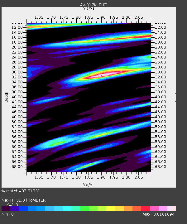
Q17K Contact Creek, Katmai, AK, USA - Earthquake Result Viewer
| Earthquake location: |
Vanuatu Islands |
| Earthquake latitude/longitude: |
-16.1/168.1 |
| Earthquake time(UTC): |
2020/08/05 (218) 12:05:36 GMT |
| Earthquake Depth: |
175 km |
| Earthquake Magnitude: |
6.4 mww |
| Earthquake Catalog/Contributor: |
NEIC PDE/us |
|
| Network: |
AV Alaska Volcano Observatory |
| Station: |
Q17K Contact Creek, Katmai, AK, USA |
| Lat/Lon: |
58.26 N/155.89 W |
| Elevation: |
1165 m |
|
| Distance: |
79.8 deg |
| Az: |
18.415 deg |
| Baz: |
215.062 deg |
| Ray Param: |
0.048275363 |
| Estimated Moho Depth: |
31.0 km |
| Estimated Crust Vp/Vs: |
1.90 |
| Assumed Crust Vp: |
6.438 km/s |
| Estimated Crust Vs: |
3.389 km/s |
| Estimated Crust Poisson's Ratio: |
0.31 |
|
| Radial Match: |
87.91931 % |
| Radial Bump: |
400 |
| Transverse Match: |
77.54803 % |
| Transverse Bump: |
400 |
| SOD ConfigId: |
21709731 |
| Insert Time: |
2020-08-19 12:12:27.631 +0000 |
| GWidth: |
2.5 |
| Max Bumps: |
400 |
| Tol: |
0.001 |
|

Signal To Noise
| Channel | StoN | STA | LTA |
| AV:Q17K: :BHZ:20200805T12:16:54.049998Z | 12.594746 | 2.0264101E-6 | 1.6089331E-7 |
| AV:Q17K: :BHN:20200805T12:16:54.049998Z | 2.7509346 | 6.212107E-7 | 2.2581804E-7 |
| AV:Q17K: :BHE:20200805T12:16:54.049998Z | 1.4207255 | 3.8927615E-7 | 2.7399815E-7 |
| Arrivals |
| Ps | 4.4 SECOND |
| PpPs | 14 SECOND |
| PsPs/PpSs | 18 SECOND |


