You are here: Home > Network List > AV - Alaska Volcano Observatory Stations List
> Station R17L Mt. Peulik Volcano, AVO PLK4, AK, USA > Earthquake Result Viewer
R17L Mt. Peulik Volcano, AVO PLK4, AK, USA - Earthquake Result Viewer
| Earthquake location: |
Vanuatu Islands |
| Earthquake latitude/longitude: |
-16.1/168.1 |
| Earthquake time(UTC): |
2020/08/05 (218) 12:05:36 GMT |
| Earthquake Depth: |
175 km |
| Earthquake Magnitude: |
6.4 mww |
| Earthquake Catalog/Contributor: |
NEIC PDE/us |
|
| Network: |
AV Alaska Volcano Observatory |
| Station: |
R17L Mt. Peulik Volcano, AVO PLK4, AK, USA |
| Lat/Lon: |
57.63 N/156.36 W |
| Elevation: |
524 m |
|
| Distance: |
79.2 deg |
| Az: |
18.573 deg |
| Baz: |
214.691 deg |
| Ray Param: |
0.048722927 |
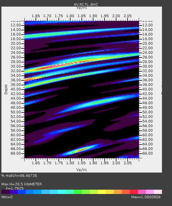
| Estimated Moho Depth: |
28.5 km |
| Estimated Crust Vp/Vs: |
1.79 |
| Assumed Crust Vp: |
6.1 km/s |
| Estimated Crust Vs: |
3.403 km/s |
| Estimated Crust Poisson's Ratio: |
0.27 |
|
| Radial Match: |
86.46735 % |
| Radial Bump: |
400 |
| Transverse Match: |
70.3129 % |
| Transverse Bump: |
400 |
| SOD ConfigId: |
21709731 |
| Insert Time: |
2020-08-19 12:12:30.969 +0000 |
| GWidth: |
2.5 |
| Max Bumps: |
400 |
| Tol: |
0.001 |
|

Signal To Noise
| Channel | StoN | STA | LTA |
| AV:R17L: :BHZ:20200805T12:16:50.474985Z | 10.573381 | 2.0925731E-6 | 1.9790954E-7 |
| AV:R17L: :BHN:20200805T12:16:50.474985Z | 1.9466497 | 3.6648817E-7 | 1.8826611E-7 |
| AV:R17L: :BHE:20200805T12:16:50.474985Z | 1.5827955 | 4.5939854E-7 | 2.9024503E-7 |
| Arrivals |
| Ps | 3.8 SECOND |
| PpPs | 13 SECOND |
| PsPs/PpSs | 17 SECOND |


