You are here: Home > Network List > CI - Caltech Regional Seismic Network Stations List
> Station EDW2 EDW2, Mojave, CA, USA > Earthquake Result Viewer
EDW2 EDW2, Mojave, CA, USA - Earthquake Result Viewer
| Earthquake location: |
Vanuatu Islands |
| Earthquake latitude/longitude: |
-16.1/168.1 |
| Earthquake time(UTC): |
2020/08/05 (218) 12:05:36 GMT |
| Earthquake Depth: |
175 km |
| Earthquake Magnitude: |
6.4 mww |
| Earthquake Catalog/Contributor: |
NEIC PDE/us |
|
| Network: |
CI Caltech Regional Seismic Network |
| Station: |
EDW2 EDW2, Mojave, CA, USA |
| Lat/Lon: |
34.88 N/117.99 W |
| Elevation: |
772 m |
|
| Distance: |
86.5 deg |
| Az: |
52.326 deg |
| Baz: |
247.729 deg |
| Ray Param: |
0.0436364 |
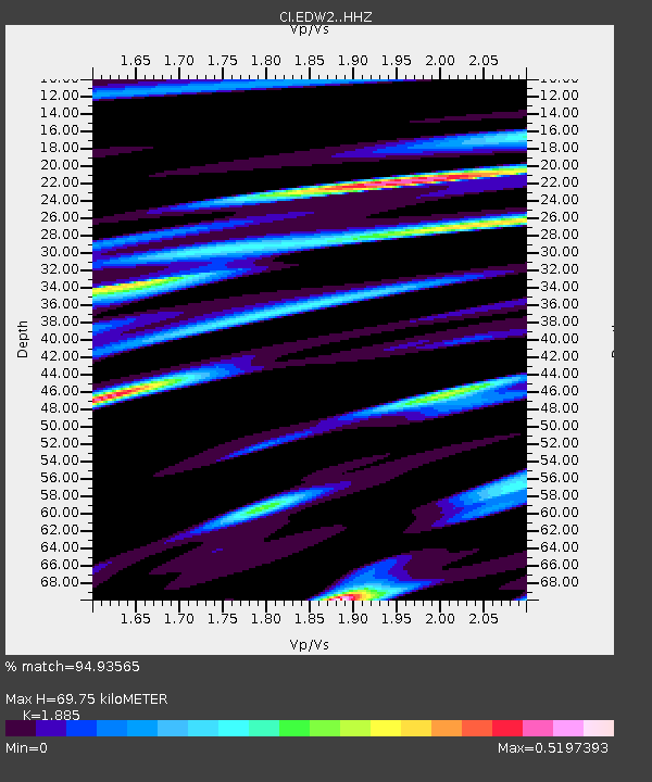
| Estimated Moho Depth: |
69.75 km |
| Estimated Crust Vp/Vs: |
1.88 |
| Assumed Crust Vp: |
6.276 km/s |
| Estimated Crust Vs: |
3.329 km/s |
| Estimated Crust Poisson's Ratio: |
0.30 |
|
| Radial Match: |
94.93565 % |
| Radial Bump: |
306 |
| Transverse Match: |
92.468216 % |
| Transverse Bump: |
347 |
| SOD ConfigId: |
21709731 |
| Insert Time: |
2020-08-19 12:14:48.971 +0000 |
| GWidth: |
2.5 |
| Max Bumps: |
400 |
| Tol: |
0.001 |
|
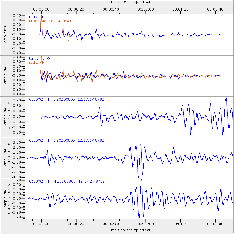
Signal To Noise
| Channel | StoN | STA | LTA |
| CI:EDW2: :HHZ:20200805T12:17:27.878Z | 6.5181766 | 7.213333E-7 | 1.106649E-7 |
| CI:EDW2: :HHN:20200805T12:17:27.878Z | 2.1927688 | 1.5445525E-7 | 7.043845E-8 |
| CI:EDW2: :HHE:20200805T12:17:27.878Z | 4.716918 | 2.3701855E-7 | 5.0248605E-8 |
| Arrivals |
| Ps | 10 SECOND |
| PpPs | 31 SECOND |
| PsPs/PpSs | 41 SECOND |


