You are here: Home > Network List > CN - Canadian National Seismograph Network Stations List
> Station DAWY Dawson, YT, CA > Earthquake Result Viewer
DAWY Dawson, YT, CA - Earthquake Result Viewer
| Earthquake location: |
Vanuatu Islands |
| Earthquake latitude/longitude: |
-16.1/168.1 |
| Earthquake time(UTC): |
2020/08/05 (218) 12:05:36 GMT |
| Earthquake Depth: |
175 km |
| Earthquake Magnitude: |
6.4 mww |
| Earthquake Catalog/Contributor: |
NEIC PDE/us |
|
| Network: |
CN Canadian National Seismograph Network |
| Station: |
DAWY Dawson, YT, CA |
| Lat/Lon: |
64.06 N/139.39 W |
| Elevation: |
771 m |
|
| Distance: |
89.5 deg |
| Az: |
20.426 deg |
| Baz: |
229.718 deg |
| Ray Param: |
0.04172658 |
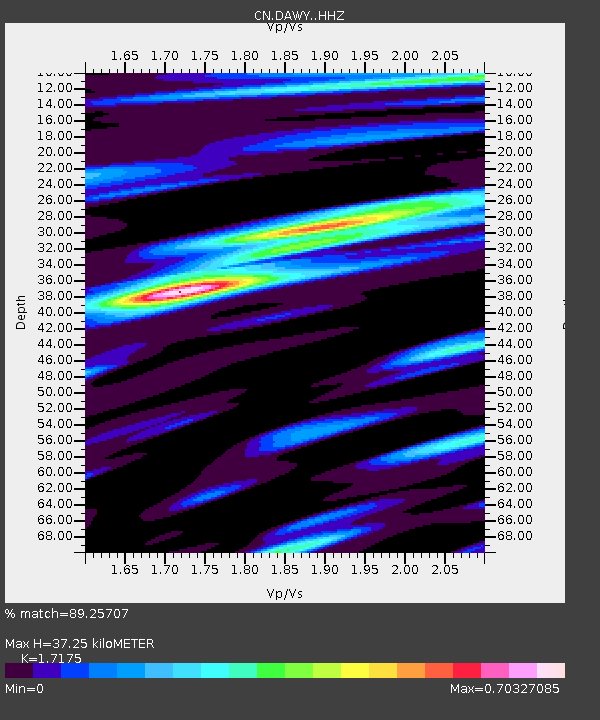
| Estimated Moho Depth: |
37.25 km |
| Estimated Crust Vp/Vs: |
1.72 |
| Assumed Crust Vp: |
6.566 km/s |
| Estimated Crust Vs: |
3.823 km/s |
| Estimated Crust Poisson's Ratio: |
0.24 |
|
| Radial Match: |
89.25707 % |
| Radial Bump: |
400 |
| Transverse Match: |
71.95944 % |
| Transverse Bump: |
400 |
| SOD ConfigId: |
21709731 |
| Insert Time: |
2020-08-19 12:16:20.132 +0000 |
| GWidth: |
2.5 |
| Max Bumps: |
400 |
| Tol: |
0.001 |
|

Signal To Noise
| Channel | StoN | STA | LTA |
| CN:DAWY: :HHZ:20200805T12:17:42.060007Z | 4.5509133 | 3.5374254E-7 | 7.773001E-8 |
| CN:DAWY: :HHN:20200805T12:17:42.060007Z | 2.3509438 | 7.86022E-8 | 3.3434315E-8 |
| CN:DAWY: :HHE:20200805T12:17:42.060007Z | 1.4397743 | 5.1706973E-8 | 3.5913253E-8 |
| Arrivals |
| Ps | 4.2 SECOND |
| PpPs | 15 SECOND |
| PsPs/PpSs | 19 SECOND |


