You are here: Home > Network List > CN - Canadian National Seismograph Network Stations List
> Station MGRB Mount Grey, BC, CA > Earthquake Result Viewer
MGRB Mount Grey, BC, CA - Earthquake Result Viewer
| Earthquake location: |
Vanuatu Islands |
| Earthquake latitude/longitude: |
-16.1/168.1 |
| Earthquake time(UTC): |
2020/08/05 (218) 12:05:36 GMT |
| Earthquake Depth: |
175 km |
| Earthquake Magnitude: |
6.4 mww |
| Earthquake Catalog/Contributor: |
NEIC PDE/us |
|
| Network: |
CN Canadian National Seismograph Network |
| Station: |
MGRB Mount Grey, BC, CA |
| Lat/Lon: |
49.00 N/124.70 W |
| Elevation: |
1310 m |
|
| Distance: |
87.8 deg |
| Az: |
37.419 deg |
| Baz: |
242.483 deg |
| Ray Param: |
0.042625338 |
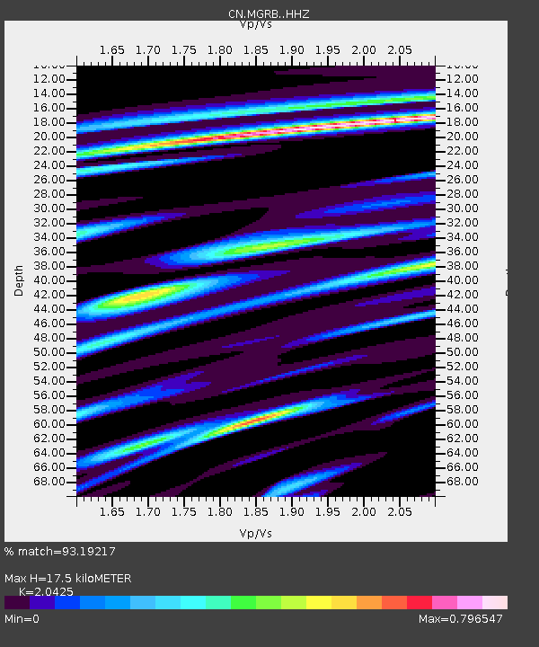
| Estimated Moho Depth: |
17.5 km |
| Estimated Crust Vp/Vs: |
2.04 |
| Assumed Crust Vp: |
6.391 km/s |
| Estimated Crust Vs: |
3.129 km/s |
| Estimated Crust Poisson's Ratio: |
0.34 |
|
| Radial Match: |
93.19217 % |
| Radial Bump: |
291 |
| Transverse Match: |
90.80659 % |
| Transverse Bump: |
400 |
| SOD ConfigId: |
21709731 |
| Insert Time: |
2020-08-19 12:16:42.738 +0000 |
| GWidth: |
2.5 |
| Max Bumps: |
400 |
| Tol: |
0.001 |
|

Signal To Noise
| Channel | StoN | STA | LTA |
| CN:MGRB: :HHZ:20200805T12:17:34.539988Z | 4.7059784 | 3.5950868E-7 | 7.639404E-8 |
| CN:MGRB: :HHN:20200805T12:17:34.539988Z | 1.2612728 | 1.1147578E-7 | 8.838356E-8 |
| CN:MGRB: :HHE:20200805T12:17:34.539988Z | 2.681341 | 1.9336898E-7 | 7.211652E-8 |
| Arrivals |
| Ps | 2.9 SECOND |
| PpPs | 8.2 SECOND |
| PsPs/PpSs | 11 SECOND |


