You are here: Home > Network List > CN - Canadian National Seismograph Network Stations List
> Station PABB Port Alberni, BC, CA > Earthquake Result Viewer
PABB Port Alberni, BC, CA - Earthquake Result Viewer
| Earthquake location: |
Vanuatu Islands |
| Earthquake latitude/longitude: |
-16.1/168.1 |
| Earthquake time(UTC): |
2020/08/05 (218) 12:05:36 GMT |
| Earthquake Depth: |
175 km |
| Earthquake Magnitude: |
6.4 mww |
| Earthquake Catalog/Contributor: |
NEIC PDE/us |
|
| Network: |
CN Canadian National Seismograph Network |
| Station: |
PABB Port Alberni, BC, CA |
| Lat/Lon: |
49.22 N/124.81 W |
| Elevation: |
3.0 m |
|
| Distance: |
87.9 deg |
| Az: |
37.189 deg |
| Baz: |
242.388 deg |
| Ray Param: |
0.04259942 |
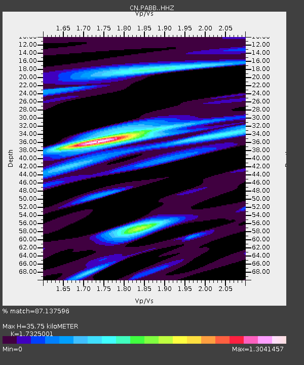
| Estimated Moho Depth: |
35.75 km |
| Estimated Crust Vp/Vs: |
1.73 |
| Assumed Crust Vp: |
6.391 km/s |
| Estimated Crust Vs: |
3.689 km/s |
| Estimated Crust Poisson's Ratio: |
0.25 |
|
| Radial Match: |
87.137596 % |
| Radial Bump: |
400 |
| Transverse Match: |
89.66363 % |
| Transverse Bump: |
357 |
| SOD ConfigId: |
21709731 |
| Insert Time: |
2020-08-19 12:17:03.231 +0000 |
| GWidth: |
2.5 |
| Max Bumps: |
400 |
| Tol: |
0.001 |
|

Signal To Noise
| Channel | StoN | STA | LTA |
| CN:PABB: :HHZ:20200805T12:17:34.709971Z | 2.950209 | 2.9465994E-7 | 9.9877646E-8 |
| CN:PABB: :HHN:20200805T12:17:34.709971Z | 1.4356012 | 6.99844E-8 | 4.874919E-8 |
| CN:PABB: :HHE:20200805T12:17:34.709971Z | 2.18858 | 1.1125247E-7 | 5.0833172E-8 |
| Arrivals |
| Ps | 4.2 SECOND |
| PpPs | 15 SECOND |
| PsPs/PpSs | 19 SECOND |


