You are here: Home > Network List > IU - Global Seismograph Network (GSN - IRIS/USGS) Stations List
> Station JOHN Johnston Island, USA > Earthquake Result Viewer
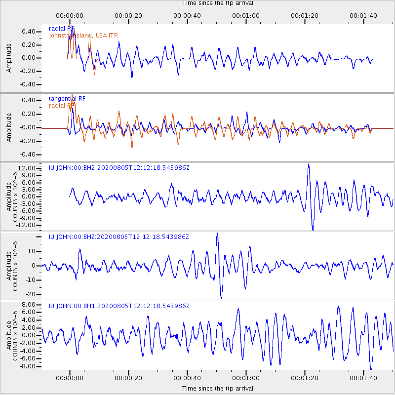
JOHN Johnston Island, USA - Earthquake Result Viewer
*The percent match for this event was below the threshold and hence no stack was calculated.
| Earthquake location: |
Vanuatu Islands |
| Earthquake latitude/longitude: |
-16.1/168.1 |
| Earthquake time(UTC): |
2020/08/05 (218) 12:05:36 GMT |
| Earthquake Depth: |
175 km |
| Earthquake Magnitude: |
6.4 mww |
| Earthquake Catalog/Contributor: |
NEIC PDE/us |
|
| Network: |
IU Global Seismograph Network (GSN - IRIS/USGS) |
| Station: |
JOHN Johnston Island, USA |
| Lat/Lon: |
16.73 N/169.53 W |
| Elevation: |
2.0 m |
|
| Distance: |
39.4 deg |
| Az: |
35.095 deg |
| Baz: |
215.223 deg |
| Ray Param: |
$rayparam |
*The percent match for this event was below the threshold and hence was not used in the summary stack. |
|
| Radial Match: |
82.28839 % |
| Radial Bump: |
367 |
| Transverse Match: |
74.58037 % |
| Transverse Bump: |
399 |
| SOD ConfigId: |
21709731 |
| Insert Time: |
2020-08-19 12:19:07.977 +0000 |
| GWidth: |
2.5 |
| Max Bumps: |
400 |
| Tol: |
0.001 |
|
Signal To Noise
| Channel | StoN | STA | LTA |
| IU:JOHN:00:BHZ:20200805T12:12:18.543986Z | 3.5096798 | 5.2788664E-6 | 1.5040878E-6 |
| IU:JOHN:00:BH1:20200805T12:12:18.543986Z | 1.385528 | 1.926677E-6 | 1.3905725E-6 |
| IU:JOHN:00:BH2:20200805T12:12:18.543986Z | 1.7872623 | 2.6982493E-6 | 1.5097108E-6 |
| Arrivals |
| Ps | |
| PpPs | |
| PsPs/PpSs | |


