You are here: Home > Network List > TA - USArray Transportable Network (new EarthScope stations) Stations List
> Station C23K Itkillik River, AK, USA > Earthquake Result Viewer
C23K Itkillik River, AK, USA - Earthquake Result Viewer
| Earthquake location: |
Vanuatu Islands |
| Earthquake latitude/longitude: |
-16.1/168.1 |
| Earthquake time(UTC): |
2020/08/05 (218) 12:05:36 GMT |
| Earthquake Depth: |
175 km |
| Earthquake Magnitude: |
6.4 mww |
| Earthquake Catalog/Contributor: |
NEIC PDE/us |
|
| Network: |
TA USArray Transportable Network (new EarthScope stations) |
| Station: |
C23K Itkillik River, AK, USA |
| Lat/Lon: |
69.84 N/150.61 W |
| Elevation: |
179 m |
|
| Distance: |
90.5 deg |
| Az: |
13.232 deg |
| Baz: |
219.383 deg |
| Ray Param: |
0.041656543 |
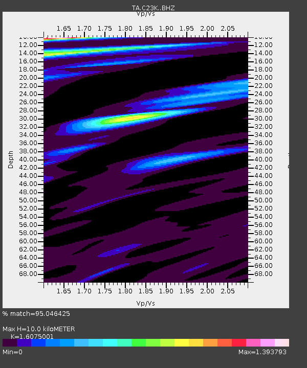
| Estimated Moho Depth: |
10.0 km |
| Estimated Crust Vp/Vs: |
1.61 |
| Assumed Crust Vp: |
6.221 km/s |
| Estimated Crust Vs: |
3.87 km/s |
| Estimated Crust Poisson's Ratio: |
0.18 |
|
| Radial Match: |
95.046425 % |
| Radial Bump: |
363 |
| Transverse Match: |
86.83364 % |
| Transverse Bump: |
390 |
| SOD ConfigId: |
21709731 |
| Insert Time: |
2020-08-19 12:22:47.714 +0000 |
| GWidth: |
2.5 |
| Max Bumps: |
400 |
| Tol: |
0.001 |
|

Signal To Noise
| Channel | StoN | STA | LTA |
| TA:C23K: :BHZ:20200805T12:17:46.774973Z | 11.277323 | 1.1329874E-6 | 1.00465996E-7 |
| TA:C23K: :BHN:20200805T12:17:46.774973Z | 3.1348002 | 2.9029886E-7 | 9.260523E-8 |
| TA:C23K: :BHE:20200805T12:17:46.774973Z | 3.808129 | 2.0334777E-7 | 5.339834E-8 |
| Arrivals |
| Ps | 1.0 SECOND |
| PpPs | 4.1 SECOND |
| PsPs/PpSs | 5.1 SECOND |


