You are here: Home > Network List > TA - USArray Transportable Network (new EarthScope stations) Stations List
> Station D17K Noatak River, AK, USA > Earthquake Result Viewer
D17K Noatak River, AK, USA - Earthquake Result Viewer
| Earthquake location: |
Vanuatu Islands |
| Earthquake latitude/longitude: |
-16.1/168.1 |
| Earthquake time(UTC): |
2020/08/05 (218) 12:05:36 GMT |
| Earthquake Depth: |
175 km |
| Earthquake Magnitude: |
6.4 mww |
| Earthquake Catalog/Contributor: |
NEIC PDE/us |
|
| Network: |
TA USArray Transportable Network (new EarthScope stations) |
| Station: |
D17K Noatak River, AK, USA |
| Lat/Lon: |
67.70 N/163.08 W |
| Elevation: |
172 m |
|
| Distance: |
86.2 deg |
| Az: |
10.631 deg |
| Baz: |
207.685 deg |
| Ray Param: |
0.043829862 |
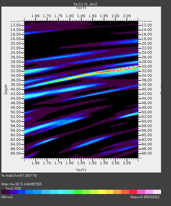
| Estimated Moho Depth: |
30.5 km |
| Estimated Crust Vp/Vs: |
2.06 |
| Assumed Crust Vp: |
6.276 km/s |
| Estimated Crust Vs: |
3.054 km/s |
| Estimated Crust Poisson's Ratio: |
0.34 |
|
| Radial Match: |
97.65776 % |
| Radial Bump: |
265 |
| Transverse Match: |
95.28136 % |
| Transverse Bump: |
388 |
| SOD ConfigId: |
21709731 |
| Insert Time: |
2020-08-19 12:22:53.254 +0000 |
| GWidth: |
2.5 |
| Max Bumps: |
400 |
| Tol: |
0.001 |
|

Signal To Noise
| Channel | StoN | STA | LTA |
| TA:D17K: :BHZ:20200805T12:17:26.599985Z | 27.850613 | 1.3445184E-6 | 4.827608E-8 |
| TA:D17K: :BHN:20200805T12:17:26.599985Z | 11.146078 | 5.50399E-7 | 4.938051E-8 |
| TA:D17K: :BHE:20200805T12:17:26.599985Z | 6.9523764 | 2.4902974E-7 | 3.581937E-8 |
| Arrivals |
| Ps | 5.2 SECOND |
| PpPs | 15 SECOND |
| PsPs/PpSs | 20 SECOND |


